IMAGES TAKEN NEAR TO
White Hart, Machen, CAERPHILLY, CF83 8QQ
Introduction
This page details the photographs taken nearby to CF83 8QQ by members of the Geograph project.
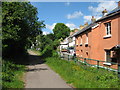
The Geograph project started in 2005 with the aim of publishing, organising and preserving representative images for every square kilometre of Great Britain, Ireland and the Isle of Man.

There are currently over 7.5m images from over14,400 individuals and you can help contribute to the project by visiting https://www.geograph.org.uk
Image Map
Images are licensed for reuse under creativecommons.org/licenses/by-sa/2.0
Notes
- Clicking on the map will re-center to the selected point.
- The higher the marker number, the further away the image location is from the centre of the postcode.
Image Listing (32 Images Found)
Images are licensed for reuse under creativecommons.org/licenses/by-sa/2.0
Image
Details
Distance
1
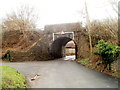
Former railway bridge near White Hart Inn, Machen
The low bridge (headroom 8' 6") now carries National Cycle Network route 4.
The left turn is into the White Hart Inn site. http://www.geograph.org.uk/photo/2763147
Image: © Jaggery
Taken: 26 Feb 2011
0.03 miles
2
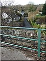
Bedwas to Machen Cycleway
Bridge over Penllwyn Lane. White Hart Inn Car Park can be seen in the right of the picture.
Image: © Kev Griffin
Taken: 15 Mar 2009
0.04 miles
3
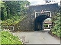
Railway bridge
A disused railway line between Bedwas and Machen.
Image: © Alan Hughes
Taken: 29 Jun 2022
0.05 miles
4
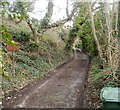
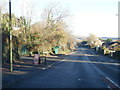
Track east from White Hart, Machen
View from the corner of the A468 and a country lane named White Hart. The track heads towards houses on the north side of Wesley Hill.
Image: © Jaggery
Taken: 26 Feb 2011
0.07 miles
5
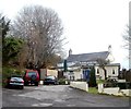
White Hart Inn, Machen
Located on the north side of the A468.
Image: © Jaggery
Taken: 26 Feb 2011
0.07 miles
6
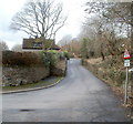
Single track road ahead, White Hart, Machen
A sign at the edge of a sharp bend on White Hart show single track road ahead.
The entrance to White Hart Inn http://www.geograph.org.uk/photo/2763147 is ahead, around the corner, under a bridge then first right.
Image: © Jaggery
Taken: 26 Feb 2011
0.07 miles
8
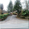
Northern end of White Hart Drive, Machen
White Hart Drive is a cul-de-sac on the south side of the A468.
Image: © Jaggery
Taken: 26 Feb 2011
0.11 miles
10
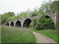
Viaduct on the Machen Forge Trail
This used to carry the line between Caerphilly and Machen.
Image: © John Light
Taken: 17 May 2012
0.15 miles