IMAGES TAKEN NEAR TO
Wesley Hill, CAERPHILLY, CF83 8QH
Introduction
This page details the photographs taken nearby to Wesley Hill, CF83 8QH by members of the Geograph project.
The Geograph project started in 2005 with the aim of publishing, organising and preserving representative images for every square kilometre of Great Britain, Ireland and the Isle of Man.

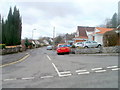
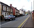
There are currently over 7.5m images from over14,400 individuals and you can help contribute to the project by visiting https://www.geograph.org.uk
Image Map
Images are licensed for reuse under creativecommons.org/licenses/by-sa/2.0
Notes
- Clicking on the map will re-center to the selected point.
- The higher the marker number, the further away the image location is from the centre of the postcode.
Image Listing (149 Images Found)
Images are licensed for reuse under creativecommons.org/licenses/by-sa/2.0
Image
Details
Distance
1
Dranllwyn Close, Machen
Viewed from Dranllwyn Lane.
Image: © Jaggery
Taken: 26 Feb 2011
0.01 miles
2
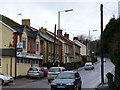
Clubland, Machen
Machen Workmen's Constitutional Club is a local village landmark on the road to Caerphilly.
Image: © Colin Smith
Taken: 7 Jan 2007
0.04 miles
3
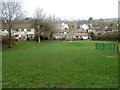
Open space, The Crescent, Machen
The area of grass extends from The Crescent to Ffwrwm Road. On the right are green railings at the edge of a children's play area. http://www.geograph.org.uk/photo/2760471
Image: © Jaggery
Taken: 26 Feb 2011
0.05 miles
4
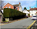
Long hedge on a Machen wall
On the west side of the road ascending from The Crescent to the A468 Commercial Road.
Image: © Jaggery
Taken: 14 Mar 2019
0.06 miles
5
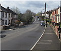
Up Commercial Road, Machen
The A468 Commercial Road ascends away from the centre of Machen towards Trethomas.
Image: © Jaggery
Taken: 14 Mar 2019
0.06 miles
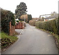
6
West along Ffwrwrm Road, Machen
Long dead-end road leading to the cul-de-sac Cae Bach.
Image: © Jaggery
Taken: 14 Mar 2019
0.07 miles
7
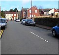
Road from The Crescent to the A468, Machen
Ascending northwards from the junction of The Crescent and Ffwrwm Road.
Image: © Jaggery
Taken: 14 Mar 2019
0.07 miles
8
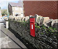
King George V postbox in a stone wall, Machen
On the approach to the Commercial Road junction. The GR on the box is short for Georgius Rex,
Latin for King George, in this case King George V who reigned from May 1910-January 1936.
Image: © Jaggery
Taken: 14 Mar 2019
0.07 miles
9
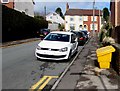
Yellow grit box in Machen
Alongside the road ascending from The Crescent to Commercial Road.
Image: © Jaggery
Taken: 14 Mar 2019
0.07 miles
10
Ty Canol Lane, Machen
Ty Canol Lane is a NW continuation of Dranllwyn Lane. Two former railway bridges mark the dividing line between the lanes. http://www.geograph.org.uk/photo/1041403
Image: © Jaggery
Taken: 26 Feb 2011
0.07 miles