1
Tudor Gardens, Machen
A single-track road leads to Tudor Gardens and New Row, at the southern edge of Machen.
Image: © Jaggery
Taken: 26 Feb 2011
0.02 miles
2
Corner of Glan yr afon and Clos Trefeddyg, Machen
Glan yr afon climbs away from the Rhymney River past the edge of Clos Trefeddyg.
Image: © Jaggery
Taken: 26 Feb 2011
0.06 miles
3
Clos Trefeddyg, Machen
Houses, built in 2004, on the east side of Clos Trefeddyg, viewed from Glan yr afon.
Image: © Jaggery
Taken: 26 Feb 2011
0.06 miles
4
Rhyd-y-gwern Lane, Machen
The lane heads SE away from Machen past signs marking the start of the National Speed Limit and another showing single track road.
Image: © Jaggery
Taken: 26 Feb 2011
0.06 miles
5
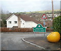
Southern boundary of Machen
The boundary sign is at the NW end of Rhyd-y-gwern Lane, http://www.geograph.org.uk/photo/2285944 on the corner of Glan yr afon.
Machen is a large village in Caerphilly County Borough.
http://www.geograph.org.uk/photo/2285962 to a closeup of the Caerphilly crest on the boundary sign.
Image: © Jaggery
Taken: 26 Feb 2011
0.06 miles
6
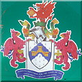
Caerphilly crest, Machen
Although on a Machen boundary sign, http://www.geograph.org.uk/photo/2285955 the crest is that of Caerphilly. Machen is a part of Caerphilly County Borough.
The ermine shield with blue invected chevron symbolises the natural beauty of the area. The castle represents Caerphilly castle, one of the largest in Europe.
The Welsh red dragon holds a Celtic wheel cross, symbolising the long history of Christianity in the area. Caerphilly's motto is "Working together for the good of all"
Image: © Jaggery
Taken: 26 Feb 2011
0.06 miles
7
Green Row, Machen
A single-track residential road running alongside the south bank of the Rhymney River, glimpses of which can be seen through the trees.
Image: © Jaggery
Taken: 26 Feb 2011
0.10 miles
8
Rhymney River flows towards Forge Bridge, Machen
Viewed from the footbridge alongside the road bridge, Forge Bridge, which carries Forge Road over the river.
Image: © Jaggery
Taken: 26 Feb 2011
0.10 miles
9
Afon Rhymni / Rhymney River, Machen Forge Trail
Machen Mountain can be seen in the distance.
Machen Forge Trail is a rural walk through villages and countryside, covering the old industrial area of Machen and Waterloo.
Image: © Kev Griffin
Taken: 5 Apr 2009
0.10 miles
10
Turtle Head Trunk, Machen Forge Trail
Yep, you read the title right. A tree trunk that looks like a decapitated Turtle's head.
Machen Forge Trail is a rural walk through villages and countryside, covering the old industrial area of Machen and Waterloo.
Image: © Kev Griffin
Taken: 5 Apr 2009
0.11 miles


