1
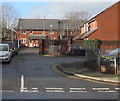
Golwg-yr-eglwys flats, Bedwas
Set back from the west side of Church Street. The sign on the right shows GOLWG-YR-EGLWYS FLATS 1-20.
Image: © Jaggery
Taken: 25 Jan 2019
0.02 miles
2
The White Hart Inn, Church Street, Bedwas
Dated 1914.
Image: © Robin Drayton
Taken: 22 Aug 2008
0.03 miles
3
Bedwas Post Office
Viewed across Church Street. Bedwas is a large village (population about 8,500) near Caerphilly.
Image: © Jaggery
Taken: 5 Mar 2011
0.03 miles
4
Bedwas Surgery and Health Centre
Medical premises on East Avenue.
Image: © Jaggery
Taken: 5 Mar 2011
0.03 miles
5
Pharmacy, florist and takeaway, Church Street, Bedwas
Three shops on Church Street, near the corner of East Avenue, are:
The Co-operative Pharmacy.
Flowers of Distinction. The premises were formerly occupied by It's a Wrap Catering.
Tsang's Bedwas Fish Bar (Chinese, Cantonese and English hot meals to take away).
Image: © Jaggery
Taken: 5 Mar 2011
0.03 miles
6
Bhaji, Bedwas
Indian takeaway on the corner of Church Street and East Avenue.
Image: © Jaggery
Taken: 5 Mar 2011
0.03 miles
7
Bethel Baptist Church, Bedwas
Image: © John Lord
Taken: 12 Sep 2011
0.03 miles
8
Bedwas Methodist Church
Part of the Gwent Hills and Vales Methodist Circuit, the church is set back from the west side of Church Street.
The tablet https://www.geograph.org.uk/photo/6033512 above the central window records that the building was erected in 1897 as a Wesleyan Church.
https://www.geograph.org.uk/photo/6033521 to a closer view of the church.
Image: © Jaggery
Taken: 25 Jan 2019
0.03 miles
9
Wesleyan Church erected 1897, Bedwas
The stone tablet is on the wall of what is now (2019) Bedwas Methodist Church. https://www.geograph.org.uk/photo/6033507
Image: © Jaggery
Taken: 25 Jan 2019
0.03 miles
10
East side of Bedwas Methodist Church
Part of the Gwent Hills and Vales Methodist Circuit, the church is set back from the west side of Church Street.
The tablet https://www.geograph.org.uk/photo/6033512 above the central window records that the building was erected in 1897 as a Wesleyan Church. https://www.geograph.org.uk/photo/6033507 to a broader view of the church.
Image: © Jaggery
Taken: 25 Jan 2019
0.03 miles


