IMAGES TAKEN NEAR TO
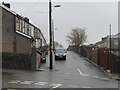
Phillips Terrace, CAERPHILLY, CF83 4HP
Introduction
This page details the photographs taken nearby to Phillips Terrace, CF83 4HP by members of the Geograph project.
The Geograph project started in 2005 with the aim of publishing, organising and preserving representative images for every square kilometre of Great Britain, Ireland and the Isle of Man.

There are currently over 7.5m images from over14,400 individuals and you can help contribute to the project by visiting https://www.geograph.org.uk
Image Map
Images are licensed for reuse under creativecommons.org/licenses/by-sa/2.0
Notes
- Clicking on the map will re-center to the selected point.
- The higher the marker number, the further away the image location is from the centre of the postcode.
Image Listing (59 Images Found)
Images are licensed for reuse under creativecommons.org/licenses/by-sa/2.0
Image
Details
Distance
1

Cenydd Terrace Senghenydd
Cenydd Terrace is the northernmost residential street in Senghenydd, adjacent to moorland. http://www.geograph.org.uk/photo/2920180
The 37 houses in Cenydd Terrace are all in this 200 metre long row on the north side of the street.
Image: © Jaggery
Taken: 27 Apr 2012
0.02 miles
2
Cenydd Terrace in Senghenydd
At the northern edge of the village, Cenydd Terrace houses are all one side of the dead-end street.
They face the backs of Graig Terrace houses on the right.
Image: © Jaggery
Taken: 15 Mar 2019
0.03 miles
3
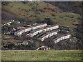
Senghenydd's Four Terraces
The terraces, in which it is claimed that every home had a victim in the Universal Colliery disaster of 1913, are seen from the Rhymney Valley Ridgeway Path.
Image: © Gareth James
Taken: 19 Jan 2014
0.03 miles
4
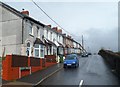
Woodland Terrace Senghenydd
This is the SW end of Woodland Terrace, a 120 metre long row of 22 houses.
All the houses in Woodland Terrace are on this side of the street.
Image: © Jaggery
Taken: 27 Apr 2012
0.04 miles
5
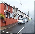
Phillips Terrace Senghenydd
This is the SW end of Phillips Terrace, a 110 metre long row of 20 houses.
All the houses in Phillips Terrace on this side of the street.
Image: © Jaggery
Taken: 27 Apr 2012
0.04 miles
6
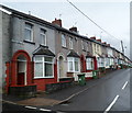
Graig Terrace, Senghenydd
This is the SW end of Graig Terrace, a 220 metre long row of 38 houses.
All the houses in Graig Terrace are on this side of the street.
Image: © Jaggery
Taken: 27 Apr 2012
0.04 miles
7
Cenydd Terrace electricity substation, Senghenydd
The green cabinet is a Western Power Distribution electricity substation.
Its identifier is CENYDD TERRACE S/S 54-2578.
Image: © Jaggery
Taken: 15 Mar 2019
0.05 miles
8
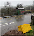
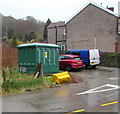
Bus stop and shelter near Cenydd Terrace, Senghenydd
In March 2019 the bus stop sign on the right shows that
this is a stop on route B to Caerphilly and route X to Cardiff.
An overturned salt/grit box is near the camera.
Image: © Jaggery
Taken: 15 Mar 2019
0.05 miles
9
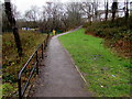
Path towards a children's playground, Senghenydd
The playground https://www.geograph.org.uk/photo/2920296 is ahead on the left.
Image: © Jaggery
Taken: 15 Mar 2019
0.07 miles
10
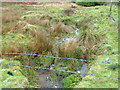
Moorland stream, Senghenydd
During a wet period in late April 2012, water flows vigorously down moorland
http://www.geograph.org.uk/photo/2920180 near the northern edge of residential Senghenydd.
Image: © Jaggery
Taken: 27 Apr 2012
0.07 miles