IMAGES TAKEN NEAR TO
Senghenydd, CAERPHILLY, CF83 4HJ
Introduction
This page details the photographs taken nearby to CF83 4HJ by members of the Geograph project.
The Geograph project started in 2005 with the aim of publishing, organising and preserving representative images for every square kilometre of Great Britain, Ireland and the Isle of Man.

There are currently over 7.5m images from over14,400 individuals and you can help contribute to the project by visiting https://www.geograph.org.uk
Image Map
Images are licensed for reuse under creativecommons.org/licenses/by-sa/2.0
Notes
- Clicking on the map will re-center to the selected point.
- The higher the marker number, the further away the image location is from the centre of the postcode.
Image Listing (79 Images Found)
Images are licensed for reuse under creativecommons.org/licenses/by-sa/2.0
Image
Details
Distance
1

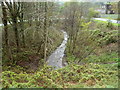
Glan Nant, Senghenydd
A stream, Glan Nant, is vigorous during a wet period at the end of April 2012.
Image: © Jaggery
Taken: 27 Apr 2012
0.04 miles
2

Single arch bridge, Senghenydd
The bridge carries an unnamed road near Woodland Terrace. The reason for a bridge here is unclear. The arch is too low for it to have been a railway bridge. The path under the bridge ends a couple of metres beyond the arch, at the blocked-off edge of a field.
Image: © Jaggery
Taken: 27 Apr 2012
0.04 miles
3

Children's playground, Senghenydd
Located near Woodland Terrace.
Image: © Jaggery
Taken: 27 Apr 2012
0.04 miles
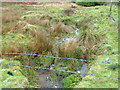
4
Glan Nant downstream, Senghenydd
A stream, Glan Nant, flows away from an unnamed road SE of Woodland Terrace.
Image: © Jaggery
Taken: 27 Apr 2012
0.04 miles
5

Looking uphill towards Woodland Terrace, Senghenydd
Viewed along an unnamed road from near where a stream, Glan Nant http://www.geograph.org.uk/photo/2920333 flows under the road. Woodland Terrace http://www.geograph.org.uk/photo/2920316 is the southernmost of four adjacent streets aligned SW-NE at the northern edge of residential Senghenydd.
Image: © Jaggery
Taken: 27 Apr 2012
0.04 miles
6
Moorland stream, Senghenydd
During a wet period in late April 2012, water flows vigorously down moorland
http://www.geograph.org.uk/photo/2920180 near the northern edge of residential Senghenydd.
Image: © Jaggery
Taken: 27 Apr 2012
0.04 miles
7
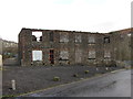
Derelict offices of the former Universal Colliery
Image: © Gareth James
Taken: 19 Jan 2014
0.05 miles
8

Corrugated metal shed west of Senghenydd
The shed is alongside this http://www.geograph.org.uk/photo/2920209 road.
Image: © Jaggery
Taken: 27 Apr 2012
0.05 miles
9
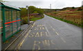
Bus terminus, Senghenydd
The bus stop, at the northern edge of residential Senghenydd, is at the end of Stagecoach route B from Caerphilly bus station. Many Stagecoach routes in the Caerphilly area are designated by a letter, not a number.
Image: © Jaggery
Taken: 27 Apr 2012
0.05 miles
10

Derelict building at Senghenydd
This was part of the old mine.
Image: © Nick Mutton 01329 000000
Taken: 23 Sep 2007
0.05 miles