1
Former colliery winding house, Llanbradach
The winding house, part of Llanbradach Colliery which closed in 1961, is now the premises
of DnA Heating Ltd who undertake plumbing, heating and related maintenance work.
Image: © Jaggery
Taken: 22 Jun 2011
0.04 miles
2
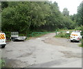
Car park and barrier at the edge of woodland, Llanbradach
At the edge of the former Llanbradach Colliery site (now used by a variety of businesses), a green barrier prevents vehicles entering a path through woodland. Viewed from Colliery Road.
Image: © Jaggery
Taken: 22 Jun 2011
0.09 miles
3
Houses at the southern end of Wingfield Crescent, Llanbradach
The long row of houses is on the west side of the road.
Image: © Jaggery
Taken: 22 Jun 2011
0.12 miles
4
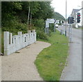
Elevated pavement on the west side of Glenview Terrace, Llanbradach
The pavement is raised above road level for about 100 metres.
Image: © Jaggery
Taken: 22 Jun 2011
0.14 miles
5
Access to woods above Llanbradach
A typical forest track at its lower end.
Image: © Graham Horn
Taken: 21 Mar 2008
0.15 miles
6
The Wingfield, Llanbradach
Pub at the southern end of Wingfield Crescent, near the corner of Rue de Ploubezre. http://www.geograph.org.uk/photo/2920150
Image: © Jaggery
Taken: 22 Jun 2011
0.15 miles
7
EC MoT & Service Centre Ltd, Llanbradach
Located in New Wingfield Garage at the southern end of Wingfield Crescent, next door to The Wingfield pub. http://www.geograph.org.uk/photo/2921695
Image: © Jaggery
Taken: 22 Jun 2011
0.15 miles
8
Llanbradach Colliery Memorial Cairn
A Road Ahead Closed temporary sign has been carelessly placed resting on the edge of the memorial located at the southern end of Wingfield Crescent, opposite EC MoT & Service Centre. http://www.geograph.org.uk/photo/2921701
Erected by Llanbradach Community Council in 1993, the memorial commemorates those who worked at the former Llanbradach Colliery, especially those who lost their lives as a result of their work.
Image: © Jaggery
Taken: 22 Jun 2011
0.15 miles
9
Large Llanbradach name sign alongside Glenview Terrace
The name sign faces Rue de Ploubezre, http://www.geograph.org.uk/photo/2920150 the link road from the A469.
Image: © Jaggery
Taken: 22 Jun 2011
0.16 miles
10
Nant Owen, Llanbradach
A stream, Nant Owen, descends a small stepped waterfall on the west side of Glenview Terrace. Nant Owen is a tributary of the Rhymney River into which it flows about 200 metres behind the camera.
The sign on the left shows that Llanbradach (and the adjoining community of Pwll-y-pant) is twinned with Ploubezre, a commune in Brittany, NW France.
Image: © Jaggery
Taken: 22 Jun 2011
0.16 miles


