IMAGES TAKEN NEAR TO
St. Cenydd Road, CAERPHILLY, CF83 2RP
Introduction
This page details the photographs taken nearby to St. Cenydd Road, CF83 2RP by members of the Geograph project.
The Geograph project started in 2005 with the aim of publishing, organising and preserving representative images for every square kilometre of Great Britain, Ireland and the Isle of Man.

There are currently over 7.5m images from over14,400 individuals and you can help contribute to the project by visiting https://www.geograph.org.uk
Image Map
Images are licensed for reuse under creativecommons.org/licenses/by-sa/2.0
Notes
- Clicking on the map will re-center to the selected point.
- The higher the marker number, the further away the image location is from the centre of the postcode.
Image Listing (50 Images Found)
Images are licensed for reuse under creativecommons.org/licenses/by-sa/2.0
Image
Details
Distance
1
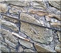
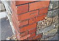
Ordnance Survey Cut Mark
This OS cut mark can be found on No162 St Cenydd Road. It marks a point 112.276m above mean sea level.
Image: © Adrian Dust
Taken: 20 Jul 2018
0.02 miles
2
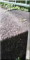
Ordnance Survey Rivet
This OS rivet can be found on the west parapet of the Nant Y Aber Bridge. It marks a point 104.766m above mean sea level.
Image: © Adrian Dust
Taken: 20 Jul 2018
0.06 miles
3
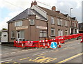
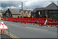
Sylvia's Tuck Shop, Trecenydd, Caerphilly
Located on St Cenydd Road (B4263), close to three schools. The temporary plastic fencing is alongside road works that are leading to long queues of traffic in the vicinity.
Image: © Jaggery
Taken: 25 Aug 2011
0.07 miles
4
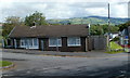
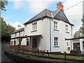
School House, Trecenydd, Caerphilly
School House is a bungalow located on the access road from St Cenydd Road to Hendre Junior School, http://www.geograph.org.uk/photo/2703532 St Cenydd Community School http://www.geograph.org.uk/photo/2703547 and St Cenydd Leisure Centre. http://www.geograph.org.uk/photo/2703544
Image: © Jaggery
Taken: 25 Aug 2011
0.07 miles
5
St Cenydd Road houses north of the A468, Caerphilly
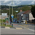
The houses are on the east side of St Cenydd Road (B4263). The bus is alongside the turning into St Cenydd Close. The sign shows 2 miles to Abertridwr, 3 miles to Senghenydd. Temporary traffic lights are controlling an alternating one-way flow of traffic past road works, leading to queues of traffic backed up for several hundred metres on both sides of the approach to the road works.
Image: © Jaggery
Taken: 25 Aug 2011
0.07 miles
6
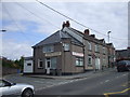
Sylvia's Tuck Shop, Trecenydd
AS it is directly opposite the entrance to a secondary school, it shouldn't lack customers.
Image: © John Lord
Taken: 9 May 2010
0.07 miles
7
Hendre Infants School, Caerphilly
Located on St Cenydd Road. Temporary traffic lights are controlling an alternating
single-lane flow of traffic, causing queues of vehicles http://www.geograph.org.uk/photo/2703486 on both sides.
Image: © Jaggery
Taken: 25 Aug 2011
0.08 miles
8
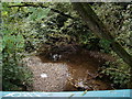
Nant-yr-aber flows away from Hendredenny Drive, Caerphilly
The brook is a tributary of the Rhymney. A few tens of metres behind the camera, Nant-yr-aber flowed past the SW edge of Brookside Close.
Image: © Jaggery
Taken: 25 Aug 2011
0.08 miles
9
The Angel, Caerphilly
Pub at the far (western) end of White Cross Lane, about 100 metres from St Cenydd Road (B4263).
Image: © Jaggery
Taken: 25 Aug 2011
0.08 miles
10
Ordnance Survey Cut Mark
This OS cut mark can be found on the SW face of the school. It marks a point 119.567m above mean sea level.
Image: © Adrian Dust
Taken: 20 Jul 2018
0.09 miles