IMAGES TAKEN NEAR TO
Cae'r Fferm, CAERPHILLY, CF83 2QD
Introduction
This page details the photographs taken nearby to Cae'r Fferm, CF83 2QD by members of the Geograph project.
The Geograph project started in 2005 with the aim of publishing, organising and preserving representative images for every square kilometre of Great Britain, Ireland and the Isle of Man.

There are currently over 7.5m images from over14,400 individuals and you can help contribute to the project by visiting https://www.geograph.org.uk
Image Map
Images are licensed for reuse under creativecommons.org/licenses/by-sa/2.0
Notes
- Clicking on the map will re-center to the selected point.
- The higher the marker number, the further away the image location is from the centre of the postcode.
Image Listing (44 Images Found)
Images are licensed for reuse under creativecommons.org/licenses/by-sa/2.0
Image
Details
Distance
1
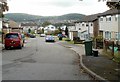
Northeast section of Cae'r Fferm, Trecenydd, Caerphilly
Cae'r Fferm is the circular road through Glenfields housing estate on the west side of St Cenydd Road.
Image: © Jaggery
Taken: 25 Aug 2011
0.03 miles
2
Entrance road to Glenfields estate, Trecenydd, Caerphilly
Viewed from First Avenue across St Cenydd Road. For road vehicles, this is the only access to and from the Glenfields Estate. The large white-on-dark green name sign lists the 12 cul-de-sacs connecting with Cae'r Fferm, the central, circular road through the housing estate.
Image: © Jaggery
Taken: 25 Aug 2011
0.06 miles
3
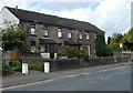
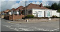
Row of four houses, St Cenydd Road, Trecenydd, Caerphilly
Alongside the houses is the First Avenue bus stop. The turning for First Avenue is ahead, out of shot on the right.
Image: © Jaggery
Taken: 25 Aug 2011
0.06 miles
4
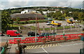
Caerphilly schools and leisure centre viewed from a footbridge
Viewed from the western side of this footbridge. http://www.geograph.org.uk/photo/2696085
The brown buildings are Hendre Junior School. The white buildings behind are St Cenydd Leisure Centre and St Cenydd Community School.
Image: © Jaggery
Taken: 25 Aug 2011
0.09 miles
5
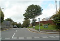
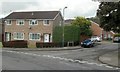
Corner of Heol-y-Pia and Cae'r Fferm, Trecenydd, Caerphilly
Heol-y-Pia on the right is a cul-de-sac connecting with Cae'r Fferm, the central, circular road through Glenfields housing estate on the west side of St Cenydd Road.
Image: © Jaggery
Taken: 25 Aug 2011
0.09 miles
6
St Cenydd Road bungalows, Trecenydd, Caerphilly
Viewed from the entrance road to Trecenydd Business Park. http://www.geograph.org.uk/photo/2695454
Image: © Jaggery
Taken: 25 Aug 2011
0.11 miles
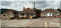
7
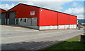
Unit G to let, Trecenydd Business Park, Caerphilly
There is a chartered surveyors' To Let sign on an industrial unit near the St Cenydd Road entrance to Trecenydd Business Park.
Image: © Jaggery
Taken: 25 Aug 2011
0.11 miles
8
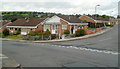
Bungalows near the corner of Trecenydd Business Park, Caerphilly
Viewed across St Cenydd Road. The two large boards show Trecenydd Business Park. The small sign pointing right shows Trecenydd Industrial Estate.
Image: © Jaggery
Taken: 25 Aug 2011
0.11 miles
9
Corner of Lon y Tresglen and Cae'r Fferm, Trecenydd, Caerphilly
Viewed across Cae'r Fferm. Part of the Glenfields housing estate on the west side of St Cenydd Road.
Image: © Jaggery
Taken: 25 Aug 2011
0.11 miles
10
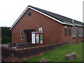
St Cenydd Rd Presbyterian Church, Trecenydd
Image: © John Lord
Taken: 9 May 2010
0.13 miles