IMAGES TAKEN NEAR TO
Brynglas, CAERPHILLY, CF83 2PL
Introduction
This page details the photographs taken nearby to Brynglas, CF83 2PL by members of the Geograph project.
The Geograph project started in 2005 with the aim of publishing, organising and preserving representative images for every square kilometre of Great Britain, Ireland and the Isle of Man.

There are currently over 7.5m images from over14,400 individuals and you can help contribute to the project by visiting https://www.geograph.org.uk
Image Map
Images are licensed for reuse under creativecommons.org/licenses/by-sa/2.0
Notes
- Clicking on the map will re-center to the selected point.
- The higher the marker number, the further away the image location is from the centre of the postcode.
Image Listing (4 Images Found)
Images are licensed for reuse under creativecommons.org/licenses/by-sa/2.0
Image
Details
Distance
1
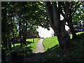
Footpath through the trees in Penyrheol
Image: © Gareth James
Taken: 26 May 2015
0.07 miles
3
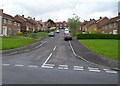
Rhiw Fach, Penyrheol,Caerphilly
Residential street viewed from Troed-y-Bryn looking towards Heol Tir Gibbon.
Rhiw fach is Welsh for little slope, an appropriate name here.
Image: © Jaggery
Taken: 1 May 2012
0.21 miles
4
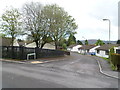
Literally a Pleasant Place to live, Penyrheol, Caerphilly
According to one source, there are 11 streets in the UK named Pleasant Place. This one is a cul-de-sac of about 30 houses, viewed from the corner of Troed-y-Bryn in the Caerphilly district of Penyrheol.
Image: © Jaggery
Taken: 1 May 2012
0.24 miles