IMAGES TAKEN NEAR TO
Porset Drive, CAERPHILLY, CF83 1PL
Introduction
This page details the photographs taken nearby to Porset Drive, CF83 1PL by members of the Geograph project.
The Geograph project started in 2005 with the aim of publishing, organising and preserving representative images for every square kilometre of Great Britain, Ireland and the Isle of Man.

There are currently over 7.5m images from over14,400 individuals and you can help contribute to the project by visiting https://www.geograph.org.uk
Image Map
Images are licensed for reuse under creativecommons.org/licenses/by-sa/2.0
Notes
- Clicking on the map will re-center to the selected point.
- The higher the marker number, the further away the image location is from the centre of the postcode.
Image Listing (36 Images Found)
Images are licensed for reuse under creativecommons.org/licenses/by-sa/2.0
Image
Details
Distance
1
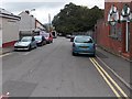
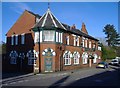
Goodrich Avenue, Caerphilly
Goodrich Avenue extends for about 100 metres from Van Road on this side to the south bank of Scouring Brook ahead. The derelict former The Goodrich pub is on the right. A notice in the doorway warns of a dangerous site. http://www.geograph.org.uk/photo/4191764
Image: © Jaggery
Taken: 3 Oct 2014
0.04 miles
2
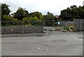
Fenced-off former pub car park in Caerphilly
On the east side of Goodrich Avenue, fencing and boulders block access to the parking area on the north side of The Goodrich pub. The pub is now (early October 2014) disused and the site is dangerous. http://www.geograph.org.uk/photo/4191764
Image: © Jaggery
Taken: 3 Oct 2014
0.09 miles
4
The Goodrich,Caerphilly
A missing letter in the sign results in the mysterious exhortation to "GO DRICH"
Image: © John Lord
Taken: 6 Jan 2010
0.09 miles
7
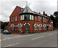
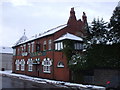
West side of The Goodrich in Caerphilly
In early October 2014, the former pub on the corner of Van Road and Goodrich Avenue was derelict. Notices warn of a dangerous site. http://www.geograph.org.uk/photo/4191764
Image: © Jaggery
Taken: 3 Oct 2014
0.11 miles
8
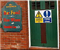
Keep clear - dangerous site in Van Road, Caerphilly
On a door of the former The Goodrich pub http://www.geograph.org.uk/photo/4191758 viewed in early October 2014.
Image: © Jaggery
Taken: 3 Oct 2014
0.11 miles
9
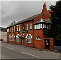
The Goodrich, Caerphilly
Viewed across Van Road in early October 2014. At first glance,
this looks like a pub still in business, but the reality is otherwise. http://www.geograph.org.uk/photo/4191764
Image: © Jaggery
Taken: 3 Oct 2014
0.11 miles
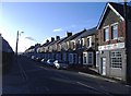
10
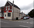
Caf? One46 in Caerphilly
At 146 Van Road, on the corner of Goodrich Avenue.
Image: © Jaggery
Taken: 3 Oct 2014
0.11 miles