IMAGES TAKEN NEAR TO
Llwyn Onn, HENGOED, CF82 8BB
Introduction
This page details the photographs taken nearby to Llwyn Onn, CF82 8BB by members of the Geograph project.
The Geograph project started in 2005 with the aim of publishing, organising and preserving representative images for every square kilometre of Great Britain, Ireland and the Isle of Man.

There are currently over 7.5m images from over14,400 individuals and you can help contribute to the project by visiting https://www.geograph.org.uk
Image Map
Images are licensed for reuse under creativecommons.org/licenses/by-sa/2.0
Notes
- Clicking on the map will re-center to the selected point.
- The higher the marker number, the further away the image location is from the centre of the postcode.
Image Listing (47 Images Found)
Images are licensed for reuse under creativecommons.org/licenses/by-sa/2.0
Image
Details
Distance
1
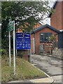
Cascade Methodist Church, Penpedairheol
Image: © Alan Hughes
Taken: 11 Jul 2023
0.03 miles
2
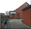
Cascade Methodist Church, Penpedairheol
The church is set back 30 metres from the south side of the B4254 Pengam Road.
Image: © Jaggery
Taken: 10 May 2013
0.03 miles
3
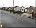
Hengoed Road bungalows, Penpedairheol
Derived from a Hindi word meaning in the style of Bengal, bungalow was originally used in English for a lightly-built house, with a veranda and one storey. In current UK usage it is a convenient word for any one-storey dwelling.
Image: © Jaggery
Taken: 22 Aug 2019
0.05 miles
4
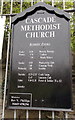
Cascade Methodist Church information board, Penpedairheol
The board is outside this http://www.geograph.org.uk/photo/3453579 church.
Image: © Jaggery
Taken: 10 May 2013
0.05 miles
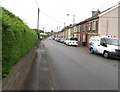
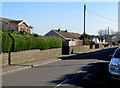
5
On-street parking, Hengoed Road, Penpedairheol
Looking to the SE towards Cefn Hengoed.
Image: © Jaggery
Taken: 22 Aug 2019
0.06 miles
6
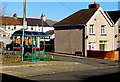
Bus stop and shelter near Berllanlwyd Street, Penpedairheol
This stop on the B4254 Pengam Road is for buses to Gilfach and Bargoed.
Image: © Jaggery
Taken: 14 Feb 2019
0.06 miles
7
Hedge and houses, Hengoed Road, Penpedairheol
Looking to the SSE away from B4254 Pengam Road and the Plough & Harrow pub. https://www.geograph.org.uk/photo/6244470
Image: © Jaggery
Taken: 22 Aug 2019
0.06 miles
8
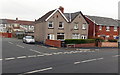
Corner of Mount Pleasant and Berllanlwyd Street, Penpedairheol
Viewed across the B4254. Mount Pleasant houses are on the right.
Image: © Jaggery
Taken: 10 May 2013
0.06 miles
9
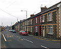
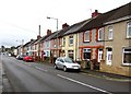
Hengoed Road, Penpedairheol
Hengoed Road heads SE away from The Square in the centre of Penpedairheol.
Image: © Jaggery
Taken: 10 May 2013
0.07 miles
10
Hengoed Road, Penpedairheol
Viewed from near the B4254 junction looking to the southeast towards Cefn Hengoed and Hengoed.
Image: © Jaggery
Taken: 14 Feb 2019
0.07 miles