IMAGES TAKEN NEAR TO
The Railway Junction, HENGOED, CF82 7TU
Introduction
This page details the photographs taken nearby to The Railway Junction, CF82 7TU by members of the Geograph project.
The Geograph project started in 2005 with the aim of publishing, organising and preserving representative images for every square kilometre of Great Britain, Ireland and the Isle of Man.

There are currently over 7.5m images from over14,400 individuals and you can help contribute to the project by visiting https://www.geograph.org.uk
Image Map
Images are licensed for reuse under creativecommons.org/licenses/by-sa/2.0
Notes
- Clicking on the map will re-center to the selected point.
- The higher the marker number, the further away the image location is from the centre of the postcode.
Image Listing (258 Images Found)
Images are licensed for reuse under creativecommons.org/licenses/by-sa/2.0
Image
Details
Distance
1
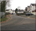
The Railway Junction, Ystrad Mynach
Located near a former railway junction, this dead-end street
on the west side of Penallta Road is named The Railway Junction. https://www.geograph.org.uk/photo/6017357
Image: © Jaggery
Taken: 5 Jan 2019
0.04 miles
2
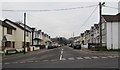
West along Pantycelyn Street, Ystrad Mynach
From Penallta Road along Pantycelyn Street towards Station Road.
Image: © Jaggery
Taken: 5 Jan 2019
0.04 miles
3
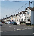
Pantycelyn Street, Ystrad Mynach
Houses on the north side of the street, viewed from the corner of Penallta Road.
Image: © Jaggery
Taken: 17 Mar 2011
0.05 miles
4
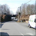
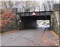
Pantycelyn Street railway bridge, Ystrad Mynach
Pantycelyn Street passes under a bridge that formerly carried a railway line.
The headroom is 10 feet 9 inches (3.3 metres). Not a route for a double-decker bus! The single-decker bus I arrived in was 9 feet 6 inches high, giving a small but comfortable clearance of 15 inches (0.4 metres).
Image: © Jaggery
Taken: 17 Mar 2011
0.05 miles
5
West side of a low bridge, Pantycelyn Street, Ystrad Mynach
Headroom shown is 10' 9". Maps show that a disused railway line is on the bridge.
Image: © Jaggery
Taken: 28 Nov 2018
0.06 miles
6
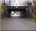
East side of a low bridge, Pantycelyn Street, Ystrad Mynach
Headroom shown is 10' 9". Maps show a disused railway line on the bridge.
The bus in the background is on bus route 7 to Blackwood.
Image: © Jaggery
Taken: 28 Nov 2018
0.06 miles
7
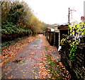
Fallen leaves on a side road in Ystrad Mynach
On the south side of Pantycelyn Road past the backs of houses
on the east side of Station Road viewed on November 28th 2018.
Image: © Jaggery
Taken: 28 Nov 2018
0.06 miles
8
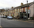
Top Shop in Ystrad Mynach
Top Shop hair salon is at 19 Lewis Street.
Image: © Jaggery
Taken: 10 Dec 2018
0.07 miles
9
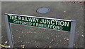
Erroneous bilingual street name sign in Ystrad Mynach
Located on the right here. https://www.geograph.org.uk/photo/6017343
The Welsh for The Railway Junction is Cyffordd y Rheilffordd, and not as shown here.
Image: © Jaggery
Taken: 5 Jan 2019
0.08 miles
10
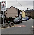
Lewis Street traffic calming, Ystrad Mynach
Traffic on the camera side must give way to oncoming vehicles. The text is also in Welsh.
Image: © Jaggery
Taken: 26 Nov 2018
0.08 miles