IMAGES TAKEN NEAR TO
Tabor Road, HENGOED, CF82 7SB
Introduction
This page details the photographs taken nearby to Tabor Road, CF82 7SB by members of the Geograph project.
The Geograph project started in 2005 with the aim of publishing, organising and preserving representative images for every square kilometre of Great Britain, Ireland and the Isle of Man.

There are currently over 7.5m images from over14,400 individuals and you can help contribute to the project by visiting https://www.geograph.org.uk
Image Map
Images are licensed for reuse under creativecommons.org/licenses/by-sa/2.0
Notes
- Clicking on the map will re-center to the selected point.
- The higher the marker number, the further away the image location is from the centre of the postcode.
Image Listing (144 Images Found)
Images are licensed for reuse under creativecommons.org/licenses/by-sa/2.0
Image
Details
Distance
1
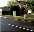
Telecoms cabinet, Tabor Road, Maesycwmmer
Also in view in November 2018 are a litter bin and a Maesycwmmer Community Council noticeboard.
Image: © Jaggery
Taken: 30 Nov 2018
0.02 miles
2
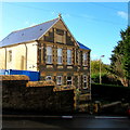
Old Police Station, Maesycwmmer
The West Avenue side of the house on the corner of Tabor Road.
The word POLICE remains legible on the faded tablet near the top of the building.
The year on the tablet is indistinct - it appears to start with 18.
The final two digits may be 88 89 98 or 99.
Image: © Jaggery
Taken: 30 Nov 2018
0.02 miles
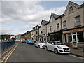
3

Row of three shops, Main Road, Maesycwmmer
Names in view on November 30th 2018 are Glam, Beautiful Blinds and Four Seasons Chinese takeaway.
Image: © Jaggery
Taken: 30 Nov 2018
0.03 miles
4

Classy Claws in Maesycwmmer
Classy Claws beauty salon at 68 Main Road is behind the red car.
Image: © Jaggery
Taken: 30 Nov 2018
0.03 miles
6
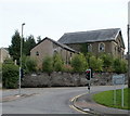
Former Tabor church, Maesycwmmer
Located on the corner of Main Road and Tabor Road. Now looking dilapidated, with broken windows and holes in the roof, Tabor Welsh Congregational Church was closed in January 2003. http://www.geograph.org.uk/photo/1711988 to a view from another angle and a potted history.
Image: © Jaggery
Taken: 27 Aug 2010
0.03 miles
7
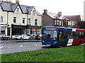
Blue, red and white bus on the A472 Main Road, Maesycwmmer
Travelling north on bus route 901 from Ystrad Mynach railway station to Blackwood bus station.
In November 2018 scheduled travelling time from terminus to terminus is 16 minutes.
Image: © Jaggery
Taken: 30 Nov 2018
0.03 miles
8
Main Road shops, Maesycwmmer
Part of a row of shops on the east side of Main Road. Seen here are Glam Hair Studio, Meridian blinds & curtains and Tsoi House, Chinese and English takeaway.
Confusingly (and possibly hazardously) for the visitor, the metal barrier is not a dual carriageway separator. There is one lane in each direction on the camera side of the barrier. The roadway on the other side of the barrier is intended for those visiting the shops : there, the flow of traffic is one way, from left to right. The barrier ends near the left edge of the photo, adjacent to a bus stop just out of shot.
Image: © Jaggery
Taken: 27 Aug 2010
0.03 miles
9
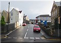
West Avenue, Maesycwmmer
Ascending from Tabor Road towards the North Avenue crossroads.
The Old Police Station https://www.geograph.org.uk/photo/5991870 is on the right.
Image: © Jaggery
Taken: 30 Nov 2018
0.04 miles
10

Semis above Main Road, Maesycwmmer
Two semi-detached houses above the east side of Main Road.
A church https://www.geograph.org.uk/photo/5989875 is behind the tree on the right.
Image: © Jaggery
Taken: 30 Nov 2018
0.04 miles