IMAGES TAKEN NEAR TO
Maesycwmmer, HENGOED, CF82 7SA
Introduction
This page details the photographs taken nearby to CF82 7SA by members of the Geograph project.
The Geograph project started in 2005 with the aim of publishing, organising and preserving representative images for every square kilometre of Great Britain, Ireland and the Isle of Man.

There are currently over 7.5m images from over14,400 individuals and you can help contribute to the project by visiting https://www.geograph.org.uk
Image Map (Loading...)


Getting Data...Please wait
Leaflet Map data © OpenStreetMap
Images are licensed for reuse under creativecommons.org/licenses/by-sa/2.0
Notes
- Clicking on the map will re-center to the selected point.
- The higher the marker number, the further away the image location is from the centre of the postcode.
Image Listing (123 Images Found)
Images are licensed for reuse under creativecommons.org/licenses/by-sa/2.0
Image
Details
Distance
1
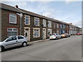
Provident Cottages, North Avenue, Maesycwmmer
Separately-named row of houses on the east side of North Avenue.
Image: © Jaggery
Taken: 30 Nov 2018
0.02 miles
2
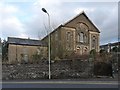
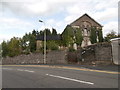
Tabor United Reformed Church, Maesycwmmer
Established in 1829 as Tabor Welsh Congregational Church, this large building dates from 1876.
It became part of the United Reformed Church in 1971, eventually closing in 2003.
For a close up of the inscription above the entrance see http://www.geograph.org.uk/photo/1712011 .
Image: © Robin Drayton
Taken: 23 Jan 2010
0.02 miles
3
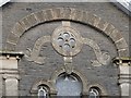
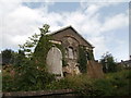
Tabor United Reformed Church (detail)
http://www.geograph.org.uk/photo/1711988
Image: © Robin Drayton
Taken: 23 Jan 2010
0.03 miles
6
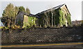
Overgrown former Tabor church, Maesycwmmer
The derelict building above the east side of Tabor Road dates from 1876.
The building was Grade II(star) listed in 1997.
Listed status is no guarantee that a building will be kept in a good state of repair.
Image: © Jaggery
Taken: 30 Nov 2018
0.04 miles
7
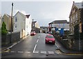
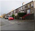
West Avenue, Maesycwmmer
Ascending from Tabor Road towards the North Avenue crossroads.
The Old Police Station https://www.geograph.org.uk/photo/5991870 is on the right.
Image: © Jaggery
Taken: 30 Nov 2018
0.04 miles
8
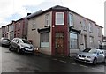
Former village post office, Maesycwmmer
On the corner of West Avenue and North Avenue viewed in November 2018.
An August 2011 Google Earth Street View shows a post office on this corner.
The red pillarbox https://www.geograph.org.uk/photo/5991861 behind the car on the left is a reminder of the building's former use.
Image: © Jaggery
Taken: 30 Nov 2018
0.04 miles
9
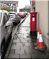
Queen Elizabeth II pillarbox, West Avenue, Maesycwmmer
Behind the car on the left here https://www.geograph.org.uk/photo/5991857 outside the former village post office.
Image: © Jaggery
Taken: 30 Nov 2018
0.04 miles