IMAGES TAKEN NEAR TO
Brookland Close, HENGOED, CF82 7RH
Introduction
This page details the photographs taken nearby to Brookland Close, CF82 7RH by members of the Geograph project.
The Geograph project started in 2005 with the aim of publishing, organising and preserving representative images for every square kilometre of Great Britain, Ireland and the Isle of Man.

There are currently over 7.5m images from over14,400 individuals and you can help contribute to the project by visiting https://www.geograph.org.uk
Image Map
Images are licensed for reuse under creativecommons.org/licenses/by-sa/2.0
Notes
- Clicking on the map will re-center to the selected point.
- The higher the marker number, the further away the image location is from the centre of the postcode.
Image Listing (130 Images Found)
Images are licensed for reuse under creativecommons.org/licenses/by-sa/2.0
Image
Details
Distance

2
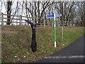
Signposts, National Cycle Route 47
On the left is a Mills style millennium milepost.
To the left, Taff Trail 4¾m, Pontypridd 10m.
To the right, Newport 15m, Crosskeys, 7m.
On the right is a more recent Loops and Links sign post.
Image: © Robin Drayton
Taken: 23 Jan 2010
0.05 miles
3
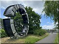
Ocean Coal Memorial
Evans & Bevan, former Welsh Anthracite (coal) mine owners, major employers in the South Wales valleys. Immortalised in this sculpture on the old rail bed at Maesycwmmer. Ocean Coal and Empire Coal, were also large mining companies owning many of the other pits.
Image: © Alan Hughes
Taken: 12 Jun 2022
0.05 miles
5
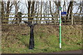
Signposts on eastern approach to Hengoed Viaduct
On the left is one of a thousand millennium mileposts to mark the creation of the national cycle network; the left arm gives the mileage to the Taff Trail and Pontypridd, the right to Newport and Crosskeys. The green and white post Image is a Loops & Links post; the nearer arm should be pointing to the left.
Image: © M J Roscoe
Taken: 24 Mar 2018
0.05 miles

8
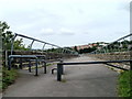
Maesycwmmer : only bicycles and pedestrians allowed on viaduct
National Cycle Network route 47 heading east approaches the edge of a former railway viaduct http://www.geograph.org.uk/photo/1679645 now part of the cycle route. Metal barriers prevent access to anything wider than a bicycle.
Image: © Jaggery
Taken: 27 Aug 2010
0.06 miles
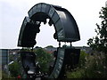
10
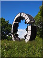
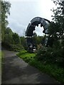
Wheel Drums Sculpture, Hengoed Viaduct
Image: © Chris Andrews
Taken: 7 Jun 2017
0.06 miles