IMAGES TAKEN NEAR TO
Forest Avenue, HENGOED, CF82 7HZ
Introduction
This page details the photographs taken nearby to Forest Avenue, CF82 7HZ by members of the Geograph project.
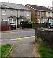
The Geograph project started in 2005 with the aim of publishing, organising and preserving representative images for every square kilometre of Great Britain, Ireland and the Isle of Man.

There are currently over 7.5m images from over14,400 individuals and you can help contribute to the project by visiting https://www.geograph.org.uk
Image Map
Images are licensed for reuse under creativecommons.org/licenses/by-sa/2.0
Notes
- Clicking on the map will re-center to the selected point.
- The higher the marker number, the further away the image location is from the centre of the postcode.
Image Listing (58 Images Found)
Images are licensed for reuse under creativecommons.org/licenses/by-sa/2.0
Image
Details
Distance
1
Warning signs - humps for 270 yards, Hengoed Avenue, Cefn Hengoed
The text on the signs is also in Welsh.
Image: © Jaggery
Taken: 22 Aug 2019
0.10 miles
2
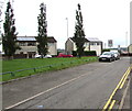
Trees, houses and rooftop solar panels, Cefn Hengoed
Looking east from Gelligaer Road towards Hengoed Avenue.
Image: © Jaggery
Taken: 22 Aug 2019
0.10 miles
3
Rooftop solar panels, Hengoed Avenue, Cefn Hengoed
Between Hengoed Road and Valley View, opposite the Gelligaer Road junction.
Image: © Jaggery
Taken: 22 Aug 2019
0.10 miles
4
Derwendeg Avenue, Cefn Hengoed
Viewed across Gelligaer Road from the corner of Lansbury Avenue.
Image: © Jaggery
Taken: 22 Aug 2019
0.11 miles
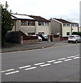
5
Gelligaer Road semis, Cefn Hengoed
Semi-detached houses on the east side of Gelligaer Road.
Image: © Jaggery
Taken: 22 Aug 2019
0.13 miles
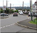
6
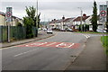
End of the 20mph speed limit, Hengoed Road, Cefn Hengoed
The 20mph speed limit in force near the village school increases to 30mph.
Hengoed Avenue is ahead on the left. The Gelligaer Road junction is on the right.
Image: © Jaggery
Taken: 22 Aug 2019
0.13 miles
7
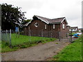
Former St Anne's Church, Cefn Hengoed
Although the nameboard https://www.geograph.org.uk/photo/6247819 remains in August 2019, St Anne's is a disused church in the Church in Wales Parish of Gelligaer, Diocese of Llandaff. The church dating from 1939 was originally Cefn Hengoed Mission Church.
Image: © Jaggery
Taken: 22 Aug 2019
0.13 miles
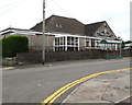
8
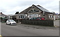
Lindsay Const Club, Cefn Hengoed
Gelligaer Road side of the club on the corner of Derwendeg Avenue. Const is short for Constitutional.
Image: © Jaggery
Taken: 22 Aug 2019
0.13 miles
9
Lindsay Constitutional Club, Gelligaer Road, Cefn Hengoed
In August 2019 the nameboard shows LINDSAY CONST CLUB.
Image: © Jaggery
Taken: 22 Aug 2019
0.13 miles
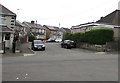
10
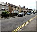
On-street parking, Gelligaer Road, Cefn Hengoed
Parking is allowed on the east side of the road.
Double yellow lines on the west side indicate no parking at any time.
Image: © Jaggery
Taken: 22 Aug 2019
0.13 miles