IMAGES TAKEN NEAR TO
Nelson Road, HENGOED, CF82 7EJ
Introduction
This page details the photographs taken nearby to Nelson Road, CF82 7EJ by members of the Geograph project.
The Geograph project started in 2005 with the aim of publishing, organising and preserving representative images for every square kilometre of Great Britain, Ireland and the Isle of Man.

There are currently over 7.5m images from over14,400 individuals and you can help contribute to the project by visiting https://www.geograph.org.uk
Image Map
Images are licensed for reuse under creativecommons.org/licenses/by-sa/2.0
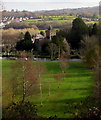
Notes
- Clicking on the map will re-center to the selected point.
- The higher the marker number, the further away the image location is from the centre of the postcode.
Image Listing (271 Images Found)
Images are licensed for reuse under creativecommons.org/licenses/by-sa/2.0
Image
Details
Distance
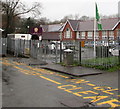
1
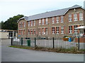
Ystrad Mynach Primary School
The school occupies a site bordered by Lisburn Road, Lewis Street and the A472. This view is of the western side of the school.
The school, now with about 400 pupils enrolled, has been on this site for a century, with the buildings and grounds updated periodically. The current name dates from 2006, on the amalgamation of Ystrad Mynach Junior School and Ystrad Mynach Infants' School.
Image: © Jaggery
Taken: 27 Aug 2010
0.04 miles
2
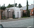
1st Ystrad Mynach Scout & Guide Hall
Located on Central Street, next door to the English Baptist Mission. http://www.geograph.org.uk/photo/2038273
Image: © Jaggery
Taken: 27 Aug 2010
0.05 miles
3
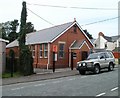
English Baptist Mission, Ystrad Mynach
Church located on Central Street.
Image: © Jaggery
Taken: 27 Aug 2010
0.05 miles
4
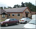
Bethany United Reformed Church, Ystrad Mynach
Located on Lisburn Road.
Image: © Jaggery
Taken: 27 Aug 2010
0.05 miles
5
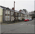
Row of houses, Church Street, Ystrad Mynach
On the south side of Church Street, west of Central Street.
Image: © Jaggery
Taken: 4 Dec 2018
0.06 miles
6
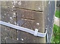
Ordnance Survey Cut Mark
This OS cut mark can be found on the NE face of Holy Trinity Church. It marks a point 110.807m above mean sea level.
Image: © Adrian Dust
Taken: 8 Jun 2019
0.06 miles
7
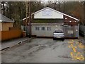
Ystrad Mynach Boys & Girls Club
At the western end of Lisburn Road Ystrad Mynach.
Image: © Jaggery
Taken: 6 Dec 2018
0.06 miles
8
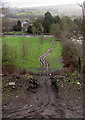
Twin tracks towards Holy Trinity Church, Ystrad Mynach
Viewed from Ystrad Mynach railway station footbridge, http://www.geograph.org.uk/photo/4807763 about 250 metres from the church.
Holy Trinity Church is part of the Parish of Ystrad Mynach and Llanbradach
in the Church in Wales Diocese of Llandaff. http://www.geograph.org.uk/photo/2065780 to a closer view and some details.
Image: © Jaggery
Taken: 28 Jan 2016
0.07 miles
9
Holy Trinity, Ystrad Mynach
The church in the Church in Wales Diocese of Llandaff was erected in 1855-1857. Grade II listed in 2001 for its architectural interest as an unusually planned and carefully detailed Gothic church designed by architect John Norton.
Image: © Jaggery
Taken: 26 Nov 2018
0.07 miles
10
Ysgol Gymraeg Bro Allta, Ystrad Mynach
Viewed from the western end of Lisburn Road. The Welsh-medium primary school was established here in 1993. Welsh-medium means that lessons are conducted through the medium of the Welsh language.
Image: © Jaggery
Taken: 6 Dec 2018
0.07 miles