IMAGES TAKEN NEAR TO
Nelson Road, HENGOED, CF82 7EG
Introduction
This page details the photographs taken nearby to Nelson Road, CF82 7EG by members of the Geograph project.
The Geograph project started in 2005 with the aim of publishing, organising and preserving representative images for every square kilometre of Great Britain, Ireland and the Isle of Man.

There are currently over 7.5m images from over14,400 individuals and you can help contribute to the project by visiting https://www.geograph.org.uk
Image Map
Images are licensed for reuse under creativecommons.org/licenses/by-sa/2.0
Notes
- Clicking on the map will re-center to the selected point.
- The higher the marker number, the further away the image location is from the centre of the postcode.
Image Listing (270 Images Found)
Images are licensed for reuse under creativecommons.org/licenses/by-sa/2.0
Image
Details
Distance
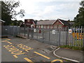
1
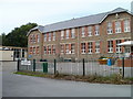
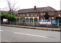
Ystrad Mynach Primary School
The school occupies a site bordered by Lisburn Road, Lewis Street and the A472. This view is of the western side of the school.
The school, now with about 400 pupils enrolled, has been on this site for a century, with the buildings and grounds updated periodically. The current name dates from 2006, on the amalgamation of Ystrad Mynach Junior School and Ystrad Mynach Infants' School.
Image: © Jaggery
Taken: 27 Aug 2010
0.01 miles
2
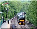
A Cardiff train arrives at Ystrad Mynach
Image: © roger geach
Taken: 5 May 2005
0.05 miles
3
Ysgol Gymraeg Bro Allta, Ystrad Mynach
Viewed from the western end of Lisburn Road. The Welsh-medium primary school was established here in 1993. Welsh-medium means that lessons are conducted through the medium of the Welsh language.
Image: © Jaggery
Taken: 6 Dec 2018
0.06 miles
4
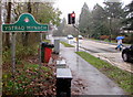
Ystrad Mynach boundary sign
Alongside the A472 near the corner of Lewis Street.
Image: © Jaggery
Taken: 28 Nov 2018
0.06 miles
5
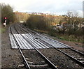
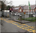
Level crossing near Ystrad Mynach railway station
For use by authorised staff only, viewed from platform 2 at Ystrad Mynach railway station.
Image: © Jaggery
Taken: 28 Jan 2016
0.06 miles
6
Ysgol Gymraeg Bro Allta, Ystrad Mynach
Welsh medium primary school.
Image: © John Lord
Taken: 26 Aug 2017
0.06 miles
7
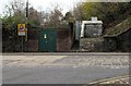
Western Power Distribution electricity substation opposite Lewis Street, Ystrad Mynach
The locked green door of the substation is alongside the A472.
Image: © Jaggery
Taken: 26 Nov 2018
0.06 miles
8
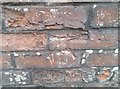
Ordnance Survey Cut Mark
This OS cut mark can be found on the Railway Station Sub-Station. It marks a point 115.623m above mean sea level.
Image: © Adrian Dust
Taken: 8 Jun 2019
0.06 miles
9
Ystrad Mynach Primary School
The north side of the school viewed across Lewis Street in Ystrad Mynach.
Image: © Jaggery
Taken: 26 Nov 2018
0.07 miles
10
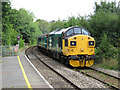
Class 37 at Ystrad Mynach
A second locomotive-hauled commuter service has now started on the Rhymney-valley line, and between its morning and evening turns it currently completes two further return trips from Cardiff to Rhymney for crew training. One of those runs is seen arriving at Ystrad Mynach station, with class 37 No. 37025 and No. 37421 working in top-and-tail formation.
Image: © Gareth James
Taken: 23 Aug 2019
0.07 miles