IMAGES TAKEN NEAR TO
Tredomen Terrace, HENGOED, CF82 7BW
Introduction
This page details the photographs taken nearby to Tredomen Terrace, CF82 7BW by members of the Geograph project.
The Geograph project started in 2005 with the aim of publishing, organising and preserving representative images for every square kilometre of Great Britain, Ireland and the Isle of Man.

There are currently over 7.5m images from over14,400 individuals and you can help contribute to the project by visiting https://www.geograph.org.uk
Image Map
Images are licensed for reuse under creativecommons.org/licenses/by-sa/2.0
Notes
- Clicking on the map will re-center to the selected point.
- The higher the marker number, the further away the image location is from the centre of the postcode.
Image Listing (82 Images Found)
Images are licensed for reuse under creativecommons.org/licenses/by-sa/2.0
Image
Details
Distance
1
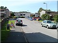
Coed-yr-Haf, Ystrad Mynach
Coed-yr-Haf is a residential road which follows a roughly T-shaped course. This view is from the bottom of the T, looking towards the junction with the top of the T.
Image: © Jaggery
Taken: 27 Aug 2010
0.09 miles
2
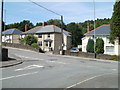
Tredomen Villas
Six semi-detached houses named Tredomen Villas, located on the north side of the A472.
Image: © Jaggery
Taken: 27 Aug 2010
0.10 miles
3
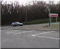
Tredomen Roundabout
35 metre diameter roundabout in the A472 at the Penallta Link Road junction.
Image: © Jaggery
Taken: 26 Nov 2018
0.11 miles
4
Ystrad Mynach direction sign in Tredomen
The sign at the edge of Tredomen Roundabout shows left (east) along
the A472 for Ystrad Mynach and the local emergency centre in a hospital.
Image: © Jaggery
Taken: 26 Nov 2018
0.11 miles
5
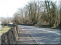
Road from Nelson approaches Tredomen
The A472 from Nelson descends towards the white-on-green Tredomen boundary sign on the right side of the road. The wall is the perimeter of the Caerphilly County Borough Council headquarters site http://www.geograph.org.uk/photo/2313317 http://www.geograph.org.uk/photo/2065000 in Tredomen Park.
Image: © Jaggery
Taken: 17 Mar 2011
0.11 miles
6

Road to Nelson leaves Tredomen
The A472 climbs away from Tredomen on the way to Nelson. Ahead, signs show the speed limit increases from 30mph to the National Speed Limit.
Image: © Jaggery
Taken: 17 Mar 2011
0.11 miles
7

The road to Nelson
The A472 climbs away from Tredomen Roundabout towards the village of Nelson Image
Image: © Jaggery
Taken: 27 Aug 2010
0.11 miles
8
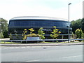
Tredomen Gateway building
Funded by the European Union's Objective 1 programme and the Welsh Assembly's Local Regeneration Fund, this glass-clad, oval-shaped building was completed in November 2005 and won the Welsh Building of the Year award in 2007.
The building has solar powered external lighting and geothermal heating. It is occupied by several small companies including a furniture design studio and a training consultancy.
Image: © Jaggery
Taken: 27 Aug 2010
0.11 miles
9
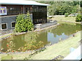
Artificial lake, Tredomen
The L-shaped artificial lake, with arms roughly 30 metres and 25 metres long, is beside the Business and Technology Centre at Tredomen.
Image: © Jaggery
Taken: 27 Aug 2010
0.11 miles