IMAGES TAKEN NEAR TO
Pant-y-Celyn Street, HENGOED, CF82 7BN
Introduction
This page details the photographs taken nearby to Pant-y-Celyn Street, CF82 7BN by members of the Geograph project.
The Geograph project started in 2005 with the aim of publishing, organising and preserving representative images for every square kilometre of Great Britain, Ireland and the Isle of Man.

There are currently over 7.5m images from over14,400 individuals and you can help contribute to the project by visiting https://www.geograph.org.uk
Image Map
Images are licensed for reuse under creativecommons.org/licenses/by-sa/2.0
Notes
- Clicking on the map will re-center to the selected point.
- The higher the marker number, the further away the image location is from the centre of the postcode.
Image Listing (237 Images Found)
Images are licensed for reuse under creativecommons.org/licenses/by-sa/2.0
Image
Details
Distance
1
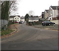
The Railway Junction, Ystrad Mynach
Located near a former railway junction, this dead-end street
on the west side of Penallta Road is named The Railway Junction. https://www.geograph.org.uk/photo/6017357
Image: © Jaggery
Taken: 5 Jan 2019
0.02 miles
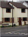
2
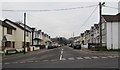
West along Pantycelyn Street, Ystrad Mynach
From Penallta Road along Pantycelyn Street towards Station Road.
Image: © Jaggery
Taken: 5 Jan 2019
0.02 miles
3
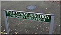
Erroneous bilingual street name sign in Ystrad Mynach
Located on the right here. https://www.geograph.org.uk/photo/6017343
The Welsh for The Railway Junction is Cyffordd y Rheilffordd, and not as shown here.
Image: © Jaggery
Taken: 5 Jan 2019
0.05 miles
4

East along Pantycelyn Street, Ystrad Mynach
Towards Penallta Road.
Image: © Jaggery
Taken: 28 Nov 2018
0.05 miles
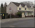
5
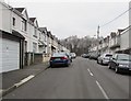
George Street, Ystrad Mynach
Dead-end street on the west side of Penallta Road.
Image: © Jaggery
Taken: 5 Jan 2019
0.06 miles
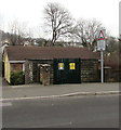
6
Bench and Royal Mail drop box on an Ystrad Mynach corner
On the corner of Penallta Road and The Railway Junction viewed in January 2019.
Part of the small drop box is rusty where paint is missing.
Image: © Jaggery
Taken: 5 Jan 2019
0.06 miles
7
Warning sign - humps for 480 yards, Penallta Road, Ystrad Mynach
Facing southbound traffic on the approach to the centre of Ystrad Mynach.
The text is also in Welsh.
Image: © Jaggery
Taken: 5 Jan 2019
0.06 miles
8
Western Power Distribution electricity substation, Penallta Road, Ystrad Mynach
Located on the left here. https://www.geograph.org.uk/photo/6017260 The substation identifier is S/S 552677
Image: © Jaggery
Taken: 5 Jan 2019
0.06 miles
9
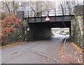
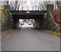
West side of a low bridge, Pantycelyn Street, Ystrad Mynach
Headroom shown is 10' 9". Maps show that a disused railway line is on the bridge.
Image: © Jaggery
Taken: 28 Nov 2018
0.06 miles
10
East side of a low bridge, Pantycelyn Street, Ystrad Mynach
Headroom shown is 10' 9". Maps show a disused railway line on the bridge.
The bus in the background is on bus route 7 to Blackwood.
Image: © Jaggery
Taken: 28 Nov 2018
0.06 miles