IMAGES TAKEN NEAR TO
Danygraig, BARGOED, CF81 9RT
Introduction
This page details the photographs taken nearby to Danygraig, CF81 9RT by members of the Geograph project.
The Geograph project started in 2005 with the aim of publishing, organising and preserving representative images for every square kilometre of Great Britain, Ireland and the Isle of Man.

There are currently over 7.5m images from over14,400 individuals and you can help contribute to the project by visiting https://www.geograph.org.uk
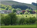
Image Map
Images are licensed for reuse under creativecommons.org/licenses/by-sa/2.0
Notes
- Clicking on the map will re-center to the selected point.
- The higher the marker number, the further away the image location is from the centre of the postcode.
Image Listing (56 Images Found)
Images are licensed for reuse under creativecommons.org/licenses/by-sa/2.0
Image
Details
Distance
1
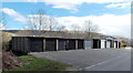
Long row of lock-up garages, Pontlottyn
The 35 metre long row of garages is between the residential street Heol-y-waun
and the Rhymney Line railway on the west bank of the Rhymney River.
Image: © Jaggery
Taken: 19 Apr 2013
0.03 miles
2
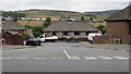
Dan-y-Graig, Pontlottyn
Bungalows below the A469 here named Southend Terrace.
Image: © Jaggery
Taken: 27 Jul 2018
0.03 miles
3
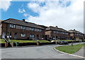
Dan-y-graig houses, Pontlottyn
Viewed from the connecting road from Heol-y-waun. Some sources shown Danygraig or Dan y Graig.
Each of the three buildings contains four houses.
Image: © Jaggery
Taken: 19 Apr 2013
0.04 miles
4
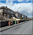
Houses at the SE end of Heol-y-waun, Pontlottyn
There are no houses on the opposite side of Heol-y-waun here. These houses have views across
the Rhymney Line railway, the banks of the Rhymney River, and the higher ground beyond.
Image: © Jaggery
Taken: 19 Apr 2013
0.04 miles
5
![Southend Terrace, Pontlottyn [2]](https://s3.geograph.org.uk/geophotos/01/16/10/1161099_6d0f47ce_120x120.jpg)
Southend Terrace, Pontlottyn [2]
The A469 on the southern outskirts of Pontlottyn.
Image: © Robin Drayton
Taken: 23 Aug 2008
0.05 miles
6
Houses at the southern end of Pontlottyn
The Rhymney River runs along the line of trees in the foreground.
This was the border between the old counties of Monmouthshire and Glamorganshire.
Now, at this point, both sides are in the Caerphilly County Borough.
Image: © Robin Drayton
Taken: 14 May 2014
0.06 miles
7
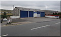
Southend Garage, Pontlottyn
Viewed across the A469 here named Southend Terrace.
Image: © Jaggery
Taken: 27 Jul 2018
0.07 miles
8
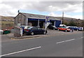
A Pontlottyn garage
Viewed across the A469 Southend Terrace, opposite Mozart Cottages. http://www.geograph.org.uk/photo/3423871
There are four named bays: MoT bay, service bay, valeting bay, tyre bay.
Image: © Jaggery
Taken: 19 Apr 2013
0.07 miles
9

SW side of a small railway bridge, Pontlottyn
Viewed from the edge of Heol-y-waun. The road under the bridge leads to Tynewydd Farm on the bank of the Rhymney River. The railway is part of the single-track section of the Rhymney Line, about 550 metres SSE of Pontlottyn station. http://www.geograph.org.uk/photo/3419166
Image: © Jaggery
Taken: 19 Apr 2013
0.08 miles
10
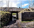
NE side of a small railway bridge, Pontlottyn
Viewed from the access lane from Tynewydd Farm. The road under the bridge leads to Heol-y-waun and the A469 in Pontlottyn. The railway is part of the single-track section of the Rhymney Line, about 550 metres SSE of Pontlottyn station. http://www.geograph.org.uk/photo/3419166
The masonry in front of the bridge, on both sides of the lane, is a remnant of an earlier bridge, at a time when the line was double track.
Image: © Jaggery
Taken: 19 Apr 2013
0.08 miles