IMAGES TAKEN NEAR TO
Board Street, BARGOED, CF81 9PP
Introduction
This page details the photographs taken nearby to Board Street, CF81 9PP by members of the Geograph project.
The Geograph project started in 2005 with the aim of publishing, organising and preserving representative images for every square kilometre of Great Britain, Ireland and the Isle of Man.

There are currently over 7.5m images from over14,400 individuals and you can help contribute to the project by visiting https://www.geograph.org.uk
Image Map
Images are licensed for reuse under creativecommons.org/licenses/by-sa/2.0
Notes
- Clicking on the map will re-center to the selected point.
- The higher the marker number, the further away the image location is from the centre of the postcode.
Image Listing (200 Images Found)
Images are licensed for reuse under creativecommons.org/licenses/by-sa/2.0
Image
Details
Distance
1
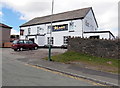
The Blast Furnace, Pontlottyn
The pub is on the corner of Board Street and River Road.
http://www.geograph.org.uk/photo/3425376 to a view of the pub name sign.
Image: © Jaggery
Taken: 19 Apr 2013
0.01 miles
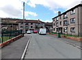
2
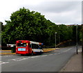
Merthyr Tydfil bus in Pontlottyn
A Stagecoach bus from Bargoed to Merthyr Tydfil travels away from Pontlottyn towards Rhymney on the B4257.
Image: © Jaggery
Taken: 27 Jul 2018
0.01 miles
3
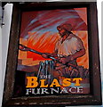
The Blast Furnace name sign, Pontlottyn
Colourfully evoking the heat of a blast furnace, the pub sign hangs from a frame on the wall here. http://www.geograph.org.uk/photo/3425360
Image: © Jaggery
Taken: 19 Apr 2013
0.01 miles
4
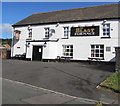
Blast Furnace, Pontlottyn
Pub on the corner of Board Street and River Road. https://www.geograph.org.uk/photo/3425376 to the name sign.
Image: © Jaggery
Taken: 4 May 2019
0.01 miles
6
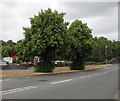
July 2018 greens and yellows in Pontlottyn
Viewed across the B4257 on July 27th 2018 during a period of very warm to hot mainly sunny weather with low rainfall which began at the start of June 2018. The green trees contrast with adjacent yellow grass.
Image: © Jaggery
Taken: 27 Jul 2018
0.02 miles
7
Junction of the B4257 and Heol Evan Wynne, Pontlottyn
Looking across the B4257 towards the eastern, dead-end, part of Heol Evan Wynne.
The western part of Heol Evan Wynne extends from the A469 to Hill Road.
Image: © Jaggery
Taken: 27 Jul 2018
0.02 miles
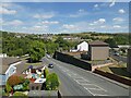
8
Board Street flats, Pontlottyn
A view from opposite the Blast Furnace. http://www.geograph.org.uk/photo/3425360 Pontlottyn Viaduct http://www.geograph.org.uk/photo/3425141 is in the background.
Image: © Jaggery
Taken: 19 Apr 2013
0.02 miles
9
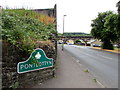
Pontlottyn boundary sign
Facing the B4257 on the corner of River Road. Pontlottyn is a village in the county borough of Caerphilly, south of the town of Rhymney and the west of the Rhymney River. Not shown here, the Welsh name is one letter shorter - Pontlotyn.
The county borough website states that the village name was recorded in 1754 as Pont Lydan, Welsh for wide bridge. Another possibility is that it is derived from Pont-y-tlotyn (poor man's (or pauper's) bridge). There is no definite explanation of the reason for either of these possible name origins.
Image: © Jaggery
Taken: 27 Jul 2018
0.02 miles
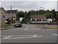
10
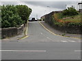
Junction of River Road and the B4257, Pontlottyn
Double yellow lines on both sides on River Road indicate no parking at any time.
The river in question is the Rhymney, here https://www.geograph.org.uk/photo/5856674 flowing below River Road.
Image: © Jaggery
Taken: 27 Jul 2018
0.03 miles