IMAGES TAKEN NEAR TO
Cross Street, BARGOED, CF81 9GR
Introduction
This page details the photographs taken nearby to Cross Street, CF81 9GR by members of the Geograph project.
The Geograph project started in 2005 with the aim of publishing, organising and preserving representative images for every square kilometre of Great Britain, Ireland and the Isle of Man.

There are currently over 7.5m images from over14,400 individuals and you can help contribute to the project by visiting https://www.geograph.org.uk
Image Map
Images are licensed for reuse under creativecommons.org/licenses/by-sa/2.0
Notes
- Clicking on the map will re-center to the selected point.
- The higher the marker number, the further away the image location is from the centre of the postcode.
Image Listing (58 Images Found)
Images are licensed for reuse under creativecommons.org/licenses/by-sa/2.0
Image
Details
Distance
1
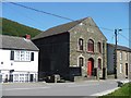
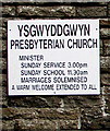
Ysgwyddgwyn Presbyterian Church, Deri
Image: © Robin Drayton
Taken: 22 Aug 2007
0.07 miles
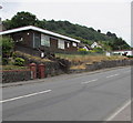
2
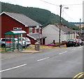
Bailey Street bus stop and shelter, Deri
This stop for buses to Bargoed.
Image: © Jaggery
Taken: 12 Jul 2018
0.08 miles
3
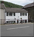
White cottage, Bailey Street, Deri
Darren Cottage is on the north side of Ysgwyddgwyn Presbyterian Church. https://www.geograph.org.uk/photo/5839871
Image: © Jaggery
Taken: 12 Jul 2018
0.08 miles
4
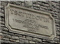
1868 tablet on Ysgwyddgwyn Presbyterian Church, Deri
The Welsh language tablet is above the windows here. https://www.geograph.org.uk/photo/5839871 It records that this was a Calvinistic Methodist place of worship when built in 1868 (replacing the original 1808 building). In 2018, this is a Presbyterian church. https://www.geograph.org.uk/photo/5839876
Image: © Jaggery
Taken: 12 Jul 2018
0.09 miles
5
Ysgwyddgwyn Presbyterian Church information board, Deri
On the wall of this https://www.geograph.org.uk/photo/5839871 church in July 2018.
Image: © Jaggery
Taken: 12 Jul 2018
0.09 miles
6
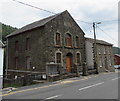
Ysgwyddgwyn Presbyterian Church, Deri
Viewed across Bailey Street. This is the 1868 rebuild of the original dating from 1808 when Deri was known as Ysgwyddgwyn. The village was renamed Deri later in the 19th century after many incomers to the area, who had come for work in the colliery, could not pronounce Ysgwyddgwyn.
Image: © Jaggery
Taken: 12 Jul 2018
0.09 miles
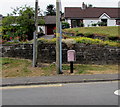
7
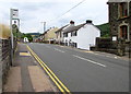
Bailey Street stop for northbound buses, Deri
Located opposite Ysgwyddgwyn Presbyterian Church https://www.geograph.org.uk/photo/5839871 this is a stop
on Stagecoach Route 1 to Merthyr Tydfil via Fochriw and Pontlottyn.
Image: © Jaggery
Taken: 12 Jul 2018
0.09 miles
8
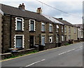
Houses on the east side of Bailey Street, Deri
South of the Old Club. https://www.geograph.org.uk/photo/5840887
Image: © Jaggery
Taken: 12 Jul 2018
0.09 miles
9
Deri Public Library
Set above the west side of Bailey Street, the library is part of Caerphilly County Borough Council's library service.
Image: © Jaggery
Taken: 12 Jul 2018
0.10 miles
10
Royal Mail drop box on the west side of Bailey Street, Deri
Image: © Jaggery
Taken: 12 Jul 2018
0.10 miles