IMAGES TAKEN NEAR TO
Cross Street, BARGOED, CF81 8RX
Introduction
This page details the photographs taken nearby to Cross Street, CF81 8RX by members of the Geograph project.
The Geograph project started in 2005 with the aim of publishing, organising and preserving representative images for every square kilometre of Great Britain, Ireland and the Isle of Man.

There are currently over 7.5m images from over14,400 individuals and you can help contribute to the project by visiting https://www.geograph.org.uk
Image Map
Images are licensed for reuse under creativecommons.org/licenses/by-sa/2.0
Notes
- Clicking on the map will re-center to the selected point.
- The higher the marker number, the further away the image location is from the centre of the postcode.
Image Listing (385 Images Found)
Images are licensed for reuse under creativecommons.org/licenses/by-sa/2.0
Image
Details
Distance
1
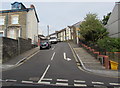
Cross Street, Bargoed
Cross Street ascends from Hanbury Road towards Greenfield Street.
Image: © Jaggery
Taken: 11 Jul 2018
0.01 miles
2
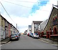
Greenfield Street, Bargoed
Greenfield Street ascends from the corner of West Street. Calfaria chapel https://www.geograph.org.uk/photo/5751415 is on the right.
Image: © Jaggery
Taken: 25 Apr 2018
0.02 miles
3
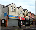
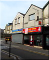
KL on a Bargoed town centre corner
KL heating, plumbing & bathroom specialists shop is at 46 Hanbury Road on the corner of Cross Street.
Image: © Jaggery
Taken: 11 Jul 2018
0.03 miles
4
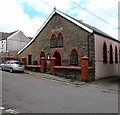
Calfaria chapel, Greenfield Street, Bargoed
Viewed from the corner of West Street. The inscription above the upper windows is 1910 CALFARIA.
Calfaria is Welsh for Calvary.
Image: © Jaggery
Taken: 25 Apr 2018
0.03 miles
5
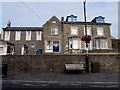
Grade II listed Bargoed Police Station
Dated 1904, the Edwardian building is part of the Gwent Police force. Grade II listed in 2002 as an early 20th century civic building of strong architectural character in a prominent location.
Image: © Jaggery
Taken: 11 Jul 2018
0.03 miles
6

Bargoed Police Station
Located on the west side of Hanbury Road, on the corner of Cross Street.
The year 1904 and COUNTY POLICE STATION are on the wall.
Out of shot on the left is the Police Court building. http://www.geograph.org.uk/photo/3464605
Image: © Jaggery
Taken: 15 May 2013
0.03 miles
7

Police Court, Bargoed
Looking like a chapel, this building on the west side of Hanbury Road has POLICE COURT engraved in stone below the pediment. Next to it on the right is the police station. http://www.geograph.org.uk/photo/3464610
Image: © Jaggery
Taken: 15 May 2013
0.04 miles
8
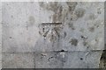
Ordnance Survey Cut Mark
This OS cut mark can be found on the Court House, Hanbury Road. It marks a point 206.200m above mean sea level.
Image: © Adrian Dust
Taken: 31 Aug 2019
0.04 miles
9
Vacant former Fortune House takeaway, Bargoed
In July 2018 a Paul Fosh Sold at Auction board is on the Hanbury Road shop in Bargoed town centre.
Image: © Jaggery
Taken: 11 Jul 2018
0.04 miles
10
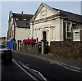
Bargoed Town Hall
The Grade II listed former Police Court erected in 1911 has been the home of Bargoed Town Council since 2014.
Image: © Jaggery
Taken: 11 Jul 2018
0.04 miles