IMAGES TAKEN NEAR TO
Greenfield Street, BARGOED, CF81 8RT

Introduction

This page details the photographs taken nearby to Greenfield Street, CF81 8RT by members of the Geograph project.

The Geograph project started in 2005 with the aim of publishing, organising and preserving representative images for every square kilometre of Great Britain, Ireland and the Isle of Man.

There are currently over 7.5m images from over14,400 individuals and you can help contribute to the project by visiting https://www.geograph.org.uk

Image Map


Images are licensed for reuse under creativecommons.org/licenses/by-sa/2.0
Notes
  • Clicking on the map will re-center to the selected point.
  • The higher the marker number, the further away the image location is from the centre of the postcode.

Image Listing (400 Images Found)

Images are licensed for reuse under creativecommons.org/licenses/by-sa/2.0
  • ...
Image
Details
Distance
1
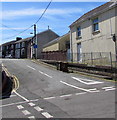
Francis Street, Bargoed
Francis Street ascends southwards away from the Upper High Street/Heolddu Road/Church Place crossroads.
Image: © Jaggery Taken: 21 Jun 2018
0.04 miles
2
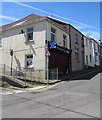
Vacant shop on a Bargoed corner in June 2018
A TO LET board is on the wall of the former Home Service Centre on the corner of Francis Street and Heolddu Road.
Image: © Jaggery Taken: 21 Jun 2018
0.06 miles
3
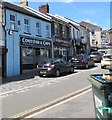
Conti Fish & Chips shop, Upper High Street, Bargoed
Text on the nameboard includes CONTINENTAL RESTAURANT and Est(ablished) 1931
Image: © Jaggery Taken: 21 Jun 2018
0.06 miles
4
Scissors in Bargoed
Scissors hair & beauty boutique at 5 Upper High Street.
Image: © Jaggery Taken: 21 Jun 2018
0.06 miles
5
Angies Dog Grooming Salon & Pet Boutique in Bargoed
Viewed across Upper High Street.
Image: © Jaggery Taken: 21 Jun 2018
0.06 miles
6
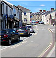
Western end of Upper High Street, Bargoed
Upper High Street ascends towards the Francis Street/Heolddu Road/Church Place crossroads.
Image: © Jaggery Taken: 21 Jun 2018
0.07 miles
7
The Plasnewydd in Bargoed
Pub in Upper High Street.
Image: © Jaggery Taken: 21 Jun 2018
0.07 miles
8
Upper High Street, Bargoed
A view ESE along Upper High Street looking towards High Street.
Image: © Jaggery Taken: 19 Apr 2013
0.07 miles
9
From High Street to Upper High Street, Bargoed
The High Street sign is at first floor level on the left. The Upper High Street sign is lower down nearby, next to a drainpipe. The bus shelter is alongside the Plasnewydd pub at 1 Upper High Street.
Image: © Jaggery Taken: 17 Jun 2019
0.07 miles
10
Heolddu Road, Bargoed
Ascending westwards from the Upper High Street/Francis Street/Church Place crossroads. The two-way traffic sign faces one-way Upper High Street.
Image: © Jaggery Taken: 21 Jun 2018
0.07 miles
  • ...