IMAGES TAKEN NEAR TO
Meadow Rise, PONTYCLUN, CF72 9TG
Introduction
This page details the photographs taken nearby to Meadow Rise, CF72 9TG by members of the Geograph project.
The Geograph project started in 2005 with the aim of publishing, organising and preserving representative images for every square kilometre of Great Britain, Ireland and the Isle of Man.

There are currently over 7.5m images from over14,400 individuals and you can help contribute to the project by visiting https://www.geograph.org.uk
Image Map
Images are licensed for reuse under creativecommons.org/licenses/by-sa/2.0
Notes
- Clicking on the map will re-center to the selected point.
- The higher the marker number, the further away the image location is from the centre of the postcode.
Image Listing (13 Images Found)
Images are licensed for reuse under creativecommons.org/licenses/by-sa/2.0
Image
Details
Distance
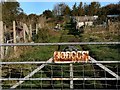
1
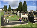
Brynna Cemetery
Llanharan Cemetery, Brynna.
Image: © Alan Hughes
Taken: 9 Mar 2017
0.14 miles
2
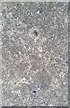
Ordnance Survey Rivet
This OS rivet can be found on the bottom step (now flush with pavement) leading into the cemetery. It marks a point 100.755m above mean sea level.
Image: © Adrian Dust
Taken: 28 Apr 2018
0.18 miles
3
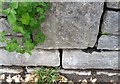
Ordnance Survey Cut Mark
This OS cut mark can be found on the wall north side of the Brynna Road. It marks a point 95.399m above mean sea level.
Image: © Adrian Dust
Taken: 28 Apr 2018
0.19 miles
4
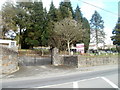
Entrance to Llanharan Cemetery
Viewed across Brynna Road. The entrance is at the SW corner of the cemetery.
Image: © Jaggery
Taken: 12 Feb 2011
0.19 miles
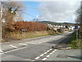
5
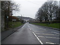
One for the road
View of the road junction at Brynna Road (the main road) and Gellifedi Road / Hillcrest, from where the picture was taken.
Just one more before calling it a day.
Image: © Ian Paterson
Taken: 2 Jun 2008
0.20 miles
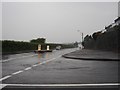
7
Western boundary of Llanharan
The view east along Brynna Road. The Llanharan boundary sign is near the SE edge of Llanharan Cemetery. On the right is the turning for Chapel Hill.
Image: © Jaggery
Taken: 12 Feb 2011
0.22 miles
8
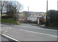
Chapel Hill, Llanharan
Chapel Hill, a no through road for motor vehicles, descends from the south side of Brynna Road.
Image: © Jaggery
Taken: 12 Feb 2011
0.22 miles
9
Brynna Road at Llanharan village boundary
Image: © Colin Pyle
Taken: 16 Dec 2013
0.24 miles
10
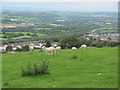
View from above Llanharan
Despite the good views, access to this footpath was difficult due to locked gates.
Image: © John Light
Taken: 24 Jun 2011
0.24 miles