IMAGES TAKEN NEAR TO
Cowbridge Road, PONTYCLUN, CF72 9NE
Introduction
This page details the photographs taken nearby to Cowbridge Road, CF72 9NE by members of the Geograph project.
The Geograph project started in 2005 with the aim of publishing, organising and preserving representative images for every square kilometre of Great Britain, Ireland and the Isle of Man.

There are currently over 7.5m images from over14,400 individuals and you can help contribute to the project by visiting https://www.geograph.org.uk
Image Map
Images are licensed for reuse under creativecommons.org/licenses/by-sa/2.0
Notes
- Clicking on the map will re-center to the selected point.
- The higher the marker number, the further away the image location is from the centre of the postcode.
Image Listing (108 Images Found)
Images are licensed for reuse under creativecommons.org/licenses/by-sa/2.0
Image
Details
Distance
1
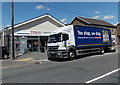
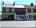
You shop, we drop in Pontyclun
The slogan is on the side of a Tesco lorry from which stock is being unloaded
to replenish the Tesco Express store in Cowbridge Road.
Image: © Jaggery
Taken: 5 Jun 2014
0.01 miles
2
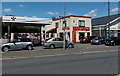
Southgate Garage, Pontyclun
Viewed across Cowbridge Road. The garage is alongside a Tesco Express http://www.geograph.org.uk/photo/4015074 on the right.
Image: © Jaggery
Taken: 5 Jun 2014
0.01 miles
3
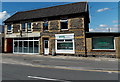
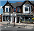
Indiaah and PPS Clinic in Pontyclun
Indiaah on the left is an Indian restaurant and takeaway in Cowbridge Road.
PPS Clinic on the right was started by physiotherapist Christine Evans MCSP in 1991.
Image: © Jaggery
Taken: 5 Jun 2014
0.02 miles
4
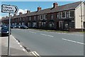
Long row of houses, Cowbridge Road, Pontyclun
The row extends for 90 metres, from the corner of Heol y Felin on this side,
to the corner of Palalwyf Avenue. Turn right here for the library. http://www.geograph.org.uk/photo/4013771
Image: © Jaggery
Taken: 5 Jun 2014
0.03 miles
5
Zeera, Pontyclun
Behind a bus stop, Zeera Indian cuisine takeaway is at 51 Cowbridge Road.
Also in view are The Flower Pot on the left, on the corner of Palalwyf Avenue,
and Scissors Pontyclun hair salon on the right.
Image: © Jaggery
Taken: 5 Jun 2014
0.03 miles
6
Vacant premises in Heol yr Orsaf, Pontyclun
The blank horizontal space above the windows used to have a nameboard showing
OWL SECURITY SERVICES LTD.
A CCTV camera, now presumably unmonitored, remains on the building in early June 2014.
Image: © Jaggery
Taken: 5 Jun 2014
0.03 miles
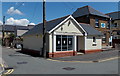
7
Pontyclun Masonic Hall
There is no name on this building on the corner of Park Crescent and the A4222 Cowbridge Road.
The silver Star of David on the side wall indicated that this could be a Jewish synagogue, but the presence of another symbol above the entrance showed that this is a Masonic Hall, confirmed by several online references.
Image: © Jaggery
Taken: 5 Jun 2014
0.04 miles
8
Talk Together in Pontyclun
Talk Together on the right is at 30 Cowbridge Road, on the corner of Heol yr Orsaf.
The nameboard shows that their business is mobiles, landlines and data.
Image: © Jaggery
Taken: 5 Jun 2014
0.04 miles
9
Fullbrook's Bistro in Pontyclun
On the right, the family-run bistro restaurant at 28 Cowbridge Road has a seating capacity of 34.
Pure Indulgence (beauty, nails, tanning etc) is on the left.
Image: © Jaggery
Taken: 5 Jun 2014
0.04 miles
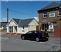
10
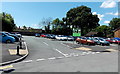
Pontyclun Community Council car park
Free public car park on the SW side of Heol yr Orsaf in Pontyclun.
Image: © Jaggery
Taken: 5 Jun 2014
0.04 miles