IMAGES TAKEN NEAR TO
Rhodfa Bryn Rhydd, PONTYCLUN, CF72 9FD
Introduction
This page details the photographs taken nearby to Rhodfa Bryn Rhydd, CF72 9FD by members of the Geograph project.
The Geograph project started in 2005 with the aim of publishing, organising and preserving representative images for every square kilometre of Great Britain, Ireland and the Isle of Man.

There are currently over 7.5m images from over14,400 individuals and you can help contribute to the project by visiting https://www.geograph.org.uk
Image Map
Images are licensed for reuse under creativecommons.org/licenses/by-sa/2.0
Notes
- Clicking on the map will re-center to the selected point.
- The higher the marker number, the further away the image location is from the centre of the postcode.
Image Listing (32 Images Found)
Images are licensed for reuse under creativecommons.org/licenses/by-sa/2.0
Image
Details
Distance
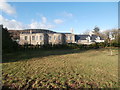
1

Lanelay Hall Housing
New housing development in the grounds of Lanelay Hall.
Image: © Alan Hughes
Taken: 5 Dec 2016
0.03 miles
2
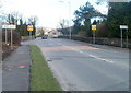
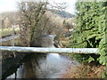
Western boundary of Talbot Green
Viewed along the A473 looking towards the stone bridge carrying the road above the Ely River. Talbot Green (Tonysguboriau in Welsh) is a village of about 2,500 inhabitants, part of Llantrisant Community Council in the County Borough of Rhondda Cynon Taf.
Image: © Jaggery
Taken: 12 Feb 2011
0.03 miles
3
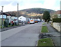
Forest Hills Drive, Talbot Green
Viewed from the Lanelay Road end.
Image: © Jaggery
Taken: 12 Feb 2011
0.05 miles
4
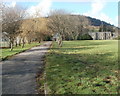
Entrance drive to Lanelay Hall, Talbot Green
Viewed from the A473. Signs on a fence state that this is South Wales Fire and Rescue Service property, and that public use of this site is prohibited. The 16th century hall, in the distance on the right, was rebuilt in Gothic style in the 19th century. It was bought by the County of Glamorgan Fire Service in 1951.
Image: © Jaggery
Taken: 12 Feb 2011
0.05 miles
5
Lanelay Hall, Talbot Green
Former stately home, now a hotel.
Image: © John Lord
Taken: 30 Jan 2019
0.06 miles

8
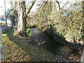
Pipe across the Ely, Talbot Green
Viewed from Lanelay Road. A large-bore pipe crosses above the Ely River.
Image: © Jaggery
Taken: 12 Feb 2011
0.09 miles

10
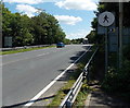
No walkers ahead on the A473 but footpath on the right near Talbot Green
Many bypass-type modern roads have no provision for walkers (no pavements) and some, as here,
show a no pedestrians sign. This is a rare example of a footpath route being available nearby.
Image: © Jaggery
Taken: 5 Jun 2014
0.12 miles