IMAGES TAKEN NEAR TO
Llanharry, PONTYCLUN, CF72 9DF
Introduction
This page details the photographs taken nearby to CF72 9DF by members of the Geograph project.
The Geograph project started in 2005 with the aim of publishing, organising and preserving representative images for every square kilometre of Great Britain, Ireland and the Isle of Man.

There are currently over 7.5m images from over14,400 individuals and you can help contribute to the project by visiting https://www.geograph.org.uk
Image Map
Images are licensed for reuse under creativecommons.org/licenses/by-sa/2.0
Notes
- Clicking on the map will re-center to the selected point.
- The higher the marker number, the further away the image location is from the centre of the postcode.
Image Listing (10 Images Found)
Images are licensed for reuse under creativecommons.org/licenses/by-sa/2.0
Image
Details
Distance
3
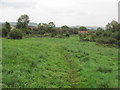
Valeways Millennium Heritage Trail near Llanharry
Open land between new housing estates.
Image: © John Light
Taken: 24 Sep 2011
0.19 miles
4
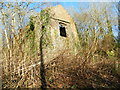
Derelict building (disused mine), Llanharry
Image: © John Lord
Taken: 19 Jan 2018
0.20 miles
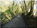
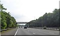
5

Rhondda Cynon Taf : M4 Motorway
The road heading through Rhondda Cynon Taf in Wales.
Image: © Lewis Clarke
Taken: 10 Apr 2014
0.20 miles
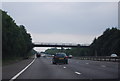
6
Track and footbridge over M4 south of Brynsadler
Four Elms Farm bridge is shown from the opposite side in Image
Image: © David Smith
Taken: 4 Jun 2018
0.21 miles
7
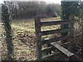
Stile and footpath
Stile and footpath leading to Castell y Mwnws.
Image: © Alan Hughes
Taken: 6 Mar 2018
0.22 miles
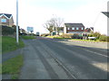
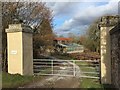
10
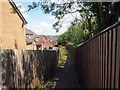
Llwybr yn Llanharri / Path in Llanharry
Llwybr cyhoeddus yn cyrraedd ystad o dai yn Llanharri.
A public footpath approaching a housing estate in Llanharry (trans. church of Harri).
Image: © Alan Richards
Taken: 28 Jul 2019
0.25 miles