IMAGES TAKEN NEAR TO
Bro-Dawel Close, PONTYCLUN, CF72 9BN
Introduction
This page details the photographs taken nearby to Bro-Dawel Close, CF72 9BN by members of the Geograph project.
The Geograph project started in 2005 with the aim of publishing, organising and preserving representative images for every square kilometre of Great Britain, Ireland and the Isle of Man.

There are currently over 7.5m images from over14,400 individuals and you can help contribute to the project by visiting https://www.geograph.org.uk
Image Map
Images are licensed for reuse under creativecommons.org/licenses/by-sa/2.0
Notes
- Clicking on the map will re-center to the selected point.
- The higher the marker number, the further away the image location is from the centre of the postcode.
Image Listing (55 Images Found)
Images are licensed for reuse under creativecommons.org/licenses/by-sa/2.0
Image
Details
Distance
1
Pontyclun Library
Located in Heol y Felin, part of the Rhondda Cynon Taf library service. The modernised, extended library has eight public access computers, a colourful children's area, a dedicated teenage area and community meeting room. It is a WiFi hotspot.
Image: © Jaggery
Taken: 5 Jun 2014
0.11 miles
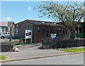
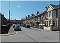
2
Maesyfelin Crescent, Pontyclun
On the south side of the A4222 Cowbridge Road.
Image: © Jaggery
Taken: 5 Jun 2014
0.12 miles
3
Pontyclun Primary School
Viewed from Heol y Felin, near Pontyclun Library. A large notice under the school name sign requests all visitors and deliveries to report to the school office through the main entrance off Palalwyf Avenue.
Image: © Jaggery
Taken: 5 Jun 2014
0.13 miles
4
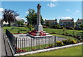
Pontyclun War Memorial
Located alongside the A4222 Cowbridge Road.
Image: © Jaggery
Taken: 5 Jun 2014
0.14 miles

6
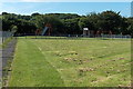
Children's play area near the Pontyclun/Brynsadler boundary
Based on the placement of nearby boundary signs, the play area is in Brynsadler
but its entrance from the south side of the A4222 Cowbridge Road is in Pontyclun.
A sign at the entrance, a few metres out of shot, shows
The playing of Golf and the exercising of dogs is prohibited.
Image: © Jaggery
Taken: 12 Jun 2014
0.15 miles
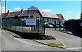
7
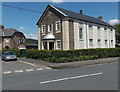
Pontyclun Masonic Hall
There is no name on this building on the corner of Park Crescent and the A4222 Cowbridge Road.
The silver Star of David on the side wall indicated that this could be a Jewish synagogue, but the presence of another symbol above the entrance showed that this is a Masonic Hall, confirmed by several online references.
Image: © Jaggery
Taken: 5 Jun 2014
0.16 miles
8
Palalwyf Avenue, Pontyclun
Looking SE from the Cowbridge Road end. I didn't recall ever seeing any other street named Palalwyf (Welsh for lime tree). One online source states that this is the only instance of an avenue (or road, street, close etc) with this name in the UK.
Image: © Jaggery
Taken: 5 Jun 2014
0.16 miles
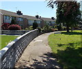
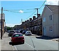
9
Park Crescent, Pontyclun
Part of a semicircle of houses on the north side of the A4222 Cowbridge Road.
Image: © Jaggery
Taken: 5 Jun 2014
0.17 miles
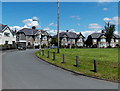
10
Castan Road towards Palalwyf Avenue, Pontyclun
Looking SW from Cerdin Avenue near Hope Penuel Presbyterian Church. http://www.geograph.org.uk/photo/4014191
Image: © Jaggery
Taken: 5 Jun 2014
0.18 miles