IMAGES TAKEN NEAR TO
The Chestnuts, PONTYCLUN, CF72 8PE
Introduction
This page details the photographs taken nearby to The Chestnuts, CF72 8PE by members of the Geograph project.
The Geograph project started in 2005 with the aim of publishing, organising and preserving representative images for every square kilometre of Great Britain, Ireland and the Isle of Man.

There are currently over 7.5m images from over14,400 individuals and you can help contribute to the project by visiting https://www.geograph.org.uk
Image Map
Images are licensed for reuse under creativecommons.org/licenses/by-sa/2.0
Notes
- Clicking on the map will re-center to the selected point.
- The higher the marker number, the further away the image location is from the centre of the postcode.
Image Listing (60 Images Found)
Images are licensed for reuse under creativecommons.org/licenses/by-sa/2.0
Image
Details
Distance
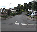
1
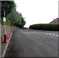
Up The Chestnuts, Miskin
The road named The Chestnuts ascends past the right turn into Elms Park. http://www.geograph.org.uk/photo/5516587
Out of shot ahead are The Drive and St David's Road.
A red bin for dog waste is on the left.
Image: © Jaggery
Taken: 29 Aug 2017
0.07 miles
2
Elms Park, Miskin
Elms Park is a cul-de-sac on the south side of the road named The Chestnuts.
Image: © Jaggery
Taken: 29 Aug 2017
0.07 miles
3
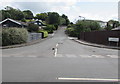
The Chestnuts, Miskin
Ascending from School Road, the road named The Chestnuts leads to several residential roads.
Image: © Jaggery
Taken: 29 Aug 2017
0.09 miles
4
St David's Road, Miskin
Viewed across the road named The Chestnuts.
Image: © Jaggery
Taken: 29 Aug 2017
0.09 miles
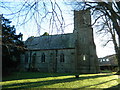
5
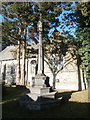
Churchyard cross, St David's Church, Miskin
Image: © John Lord
Taken: 1 Dec 2017
0.10 miles
7
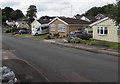
St David's Road bungalows, Miskin
Originally, bungalow was used in English for a lightly-built house, with a veranda and one storey.
In current UK usage it is a convenient word for any one-storey dwelling.
Image: © Jaggery
Taken: 29 Aug 2017
0.10 miles
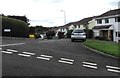
8
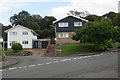
Corner of Beechlea Close and The Chestnuts, Miskin
Houses at the southern end of Beechlea Close viewed across the road named The Chestnuts.
Image: © Jaggery
Taken: 29 Aug 2017
0.10 miles
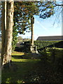
9
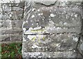
Ordnance Survey Cut Mark
This OS cut mark can be found on the south face of St David's Church. It marks a point 48.734m above mean sea level.
Image: © Adrian Dust
Taken: 19 Sep 2021
0.11 miles