IMAGES TAKEN NEAR TO
Tynant Road, PONTYCLUN, CF72 8FG
Introduction
This page details the photographs taken nearby to Tynant Road, CF72 8FG by members of the Geograph project.
The Geograph project started in 2005 with the aim of publishing, organising and preserving representative images for every square kilometre of Great Britain, Ireland and the Isle of Man.

There are currently over 7.5m images from over14,400 individuals and you can help contribute to the project by visiting https://www.geograph.org.uk
Image Map
Images are licensed for reuse under creativecommons.org/licenses/by-sa/2.0
Notes
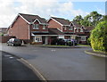
- Clicking on the map will re-center to the selected point.
- The higher the marker number, the further away the image location is from the centre of the postcode.
Image Listing (30 Images Found)
Images are licensed for reuse under creativecommons.org/licenses/by-sa/2.0
Image
Details
Distance
1
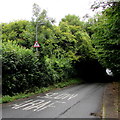
Warning signs, Tynant Road, Creigiau
A road narrows sign and a pedestrians sign on a lamppost face Tynant Road near an English/Welsh SLOW/ARAF painted on the road surface. Behind the camera, signs http://www.geograph.org.uk/photo/5524926 facing the A4119 show that the road ahead is unsuitable for heavy goods vehicles.
Image: © Jaggery
Taken: 29 Aug 2017
0.07 miles
2
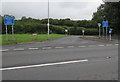
A4119 bus stop and shelter east of Groesfaen
In August 2017 timetables in the shelter alongside the A4119 show
bus route 122 to Cardiff city centre via Danescourt & Llandaff and
bus route 124 to Cardiff city centre via Creigiau & Llandaff.
Image: © Jaggery
Taken: 29 Aug 2017
0.08 miles
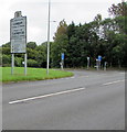
3
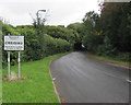
Welcome to/Croeso i/ Creigiau
The English/Welsh sign is alongside Tynant Road near the A4119 junction.
Creigiau is a village in the northwest of the City and County of Cardiff, about 13km (8 miles)
from Cardiff city centre. The village of Groesfaen in Rhondda Cynon Taf is nearby.
Image: © Jaggery
Taken: 29 Aug 2017
0.10 miles
4
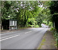
Unsuitable for heavy goods vehicles signs, Tynant Road near Creigiau
The English/Welsh signs face the A4119 at the southern end of Tynant Road.
The Welcome to Creigiau sign http://www.geograph.org.uk/photo/5524915 is in the background.
Image: © Jaggery
Taken: 29 Aug 2017
0.10 miles
5
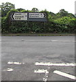
Directions and distances signs near Groesfaen
On the south side of the A4119 facing Tynant Road, http://www.geograph.org.uk/photo/5524926 8 miles from Cardiff (city centre),
a quarter of a mile from Groesfaen and 4 miles from Llantrisant.
Image: © Jaggery
Taken: 29 Aug 2017
0.11 miles
6
City and County of Cardiff boundary sign
Facing the A4119 near Groesfaen in Rhondda Cynon Taf county borough.
This boundary sign is about 13km (8 miles) from Cardiff city centre.
The sign which is also in Welsh shows the names of the five foreign
cities with which Cardiff is twinned.
The Creigiau boundary sign http://www.geograph.org.uk/photo/5524915 is in the background.
Image: © Jaggery
Taken: 29 Aug 2017
0.12 miles
7
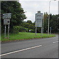
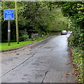
Direction and distances sign near the Cardiff boundary sign
The sign is alongside the A4119 from Groesfaen in the county borough of Rhondda Cynon Taf near the City and County of Cardiff boundary sign 13km (8 miles) from Cardiff city centre. It's a mile and three quarters to (the centre of) Creigiau, two and a half miles to Pentyrch and four miles to Efail isaf. An English/Welsh sign warns of speed cameras nearby.
Image: © Jaggery
Taken: 29 Aug 2017
0.13 miles
8
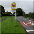
Welcome to/Croeso i Groes-faen
Facing the A4119 from the City and County of Cardiff. Spelt Groes-faen in Welsh, the village
in the county borough of Rhondda Cynon Taf is sometimes spelt Groesfaen in English.
The National Speed Limit on the A4119 drops to 30mph ahead.
Image: © Jaggery
Taken: 29 Aug 2017
0.17 miles
9
Dol-y-Felin, Creigiau
Cul-de-sac on the south side of Ffordd Dinefwr.
Most of the streets in Creigiau have Welsh-only names.
Image: © Jaggery
Taken: 13 Sep 2017
0.18 miles
10
Unsuitable route for heavy goods vehicles in Creigiau
The English/Welsh sign faces Tynant Road south of the Ffordd Dinefwr junction.
Image: © Jaggery
Taken: 13 Sep 2017
0.19 miles