IMAGES TAKEN NEAR TO
Goscombe Place, COWBRIDGE, CF71 7UD
Introduction
This page details the photographs taken nearby to Goscombe Place, CF71 7UD by members of the Geograph project.
The Geograph project started in 2005 with the aim of publishing, organising and preserving representative images for every square kilometre of Great Britain, Ireland and the Isle of Man.

There are currently over 7.5m images from over14,400 individuals and you can help contribute to the project by visiting https://www.geograph.org.uk
Image Map
Images are licensed for reuse under creativecommons.org/licenses/by-sa/2.0
Notes
- Clicking on the map will re-center to the selected point.
- The higher the marker number, the further away the image location is from the centre of the postcode.
Image Listing (52 Images Found)
Images are licensed for reuse under creativecommons.org/licenses/by-sa/2.0
Image
Details
Distance
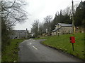
1
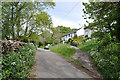
Lane to the A48 with terraced houses - Llantrithyd
Image: © Mick Lobb
Taken: 10 Apr 2009
0.01 miles
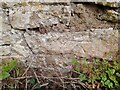
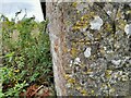
3
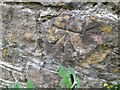
Ordnance Survey Cut Mark
This OS cut mark can be found on the roadside building at New House Farm. It marks a point 62.134m above mean sea level.
Image: © Adrian Dust
Taken: 28 Sep 2022
0.05 miles
4
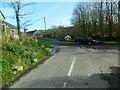
Looking towards the crossroads, Llantrithyd
Image: © John Lord
Taken: 7 Feb 2014
0.06 miles
5
Ordnance Survey Cut Mark
This OS cut mark can be found on the wall of Cross House. It marks a point 53.038m above mean sea level.
Image: © Adrian Dust
Taken: 28 Sep 2022
0.07 miles
6
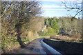
Approaching bend - Llantrithyd
The lane that passes through Llantrithyd is in regular use as a rat run to the A48 by those who live to the west of Llantwit Major and the town itself to reach the A48 and thence Cardiff. A journey not without its risks!
Image: © Mick Lobb
Taken: 11 Dec 2009
0.07 miles
7
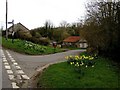
Crossroads, Llantrithyd
The edge of the square runs through the middle of this crossroads. This picture features the bits that are in this grid.
Image: © Stuart Wilding
Taken: 11 Mar 2007
0.08 miles
9
Ordnance Survey Cut Mark
This OS cut mark can be found on the barn at Cross House. It marks a point 54.437m above mean sea level.
Image: © Adrian Dust
Taken: 28 Sep 2022
0.09 miles
10
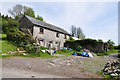
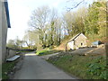
Barn awaiting conversion - Llantrithyd
Although there are signs of work in the immediate vicinity, the barn, in its near idyllic setting, has had no apparent work carried out in recent times.
Image: © Mick Lobb
Taken: 10 May 2009
0.10 miles