IMAGES TAKEN NEAR TO
High Street, COWBRIDGE, CF71 7NA
Introduction
This page details the photographs taken nearby to High Street, CF71 7NA by members of the Geograph project.
The Geograph project started in 2005 with the aim of publishing, organising and preserving representative images for every square kilometre of Great Britain, Ireland and the Isle of Man.

There are currently over 7.5m images from over14,400 individuals and you can help contribute to the project by visiting https://www.geograph.org.uk
Image Map
Images are licensed for reuse under creativecommons.org/licenses/by-sa/2.0
Notes
- Clicking on the map will re-center to the selected point.
- The higher the marker number, the further away the image location is from the centre of the postcode.
Image Listing (242 Images Found)
Images are licensed for reuse under creativecommons.org/licenses/by-sa/2.0
Image
Details
Distance
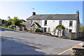
1
High Street - viewed from The Limes
Image: © Betty Longbottom
Taken: 28 Jun 2019
0.01 miles
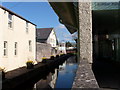
2
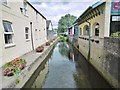
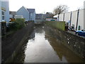
Cowbridge, River Thaw
Looking upstream from High Street.
Image: © Mike Faherty
Taken: 12 Jul 2016
0.01 miles
4
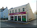
Filco, Cowbridge
The High Street supermarket is alongside the River Thaw http://www.geograph.org.uk/photo/3430812 on the left.
Established in 1946, Filco is a family-run business with several stores in South Wales.
Image: © Jaggery
Taken: 19 Jan 2012
0.02 miles
5
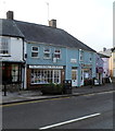
The Cowbridge Bookshop, Cowbridge
The bookshop is at 72 Eastgate.
Image: © Jaggery
Taken: 19 Jan 2012
0.02 miles
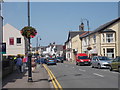
6
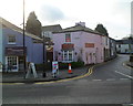
The Limes, Cowbridge
The Limes is the side street on the right. Viewed across Eastgate.
Image: © Jaggery
Taken: 19 Jan 2012
0.03 miles
7
Penny Lane shopping precinct
Penny Lane leading to Willow Walk via footbridge over River Thaw. Circular building is Italian Gelateria and coffee bar.
Image: © Ron Speed
Taken: 29 Mar 2009
0.03 miles
8
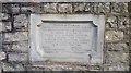
Old Boundary Marker
Bridge Marker set in former bridge parapet on north side of the A4222 High Street (formerly the A48). COWBRIDGE WITH LLANBLETHIAN parish. Inscribed BOROUGH OF COWBRIDGE / THE BRIDGE (OF VERY ANCIENT ORIGIN) OVER, AND / THE ROAD ALONGSIDE THE RIVER WERE WIDENED / AND IMPROVED IN THE YEAR 1911.
Milestone Society National ID: GLA_COW02br
Image: © D Elis-Williams
Taken: 5 Dec 2019
0.03 miles
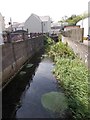
9
River Thaw flows away from High Street, Cowbridge
After flowing through a straight http://www.geograph.org.uk/photo/3430811 110 metre long man-made channel on both sides of, and under, High Street, the Thaw resumes its natural course beyond the house ahead.
Image: © Jaggery
Taken: 19 Jan 2012
0.03 miles