Old Boundary Marker
Introduction
The photograph on this page of Old Boundary Marker by D Elis-Williams as part of the Geograph project.
The Geograph project started in 2005 with the aim of publishing, organising and preserving representative images for every square kilometre of Great Britain, Ireland and the Isle of Man.

There are currently over 7.5m images from over 14,400 individuals and you can help contribute to the project by visiting https://www.geograph.org.uk
Old Boundary Marker
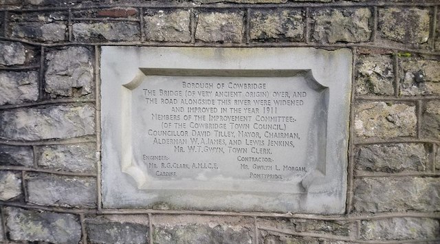
Image: © D Elis-Williams Taken: 5 Dec 2019
Bridge Marker set in former bridge parapet on north side of the A4222 High Street (formerly the A48). COWBRIDGE WITH LLANBLETHIAN parish. Inscribed BOROUGH OF COWBRIDGE / THE BRIDGE (OF VERY ANCIENT ORIGIN) OVER, AND / THE ROAD ALONGSIDE THE RIVER WERE WIDENED / AND IMPROVED IN THE YEAR 1911. Milestone Society National ID: GLA_COW02br
Images are licensed for reuse under creativecommons.org/licenses/by-sa/2.0
Image Location
Latitude
51.461182
Longitude
-3.445568