1
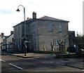
Cowbridge Youth Centre
Located in the former magistrates court on the south side of Cowbridge Police Station, http://www.geograph.org.uk/photo/3667278 the Youth Centre provides a wide range of activities such as issue-based work, arts, sports, residential opportunities, citizenship, community projects, as well as providing advice and information.
International Youth Exchanges have been a major part of the centre's programme. Young people have travelled throughout Europe via the Youth in Action Programme, and many have participated in the European Volunteer Programme or Erasmus programme to work or study in a European country.
Image: © Jaggery
Taken: 19 Jan 2012
0.03 miles
2
Cowbridge Police Station and Thira Cottage
Image: © Mick Lobb
Taken: 20 Apr 2009
0.05 miles
3
Spring dandelions in old Hall Gardens
The white building is the Health Centre
Image: © Ron Speed
Taken: 18 Apr 2010
0.05 miles
4
Bench Mark, Cowbridge Police Station
The bench mark is on the front of the building adjacent to the right hand rainwater pipe.
Its elevation is shown on the 1906 OS map as 95.4ft
Image: © Guy Butler-Madden
Taken: 23 Feb 2012
0.05 miles
5
Ordnance Survey Cut Mark
This OS cut mark can be found on the Police Station, Westgate. It marks a point 28.983m above mean sea level.
Image: © Adrian Dust
Taken: 19 Apr 2018
0.05 miles
6
Cowbridge Police Station
Part of the South Wales Police force, the station is alongside the A4222 Westgate.
A sign points right towards the youth centre. http://www.geograph.org.uk/photo/3638801
Image: © Jaggery
Taken: 19 Jan 2012
0.06 miles
7
Old Hall Gardens Cowbridge
Old Hall Gardens with Health Centre and Library
Image: © Ron Speed
Taken: 20 Mar 2009
0.06 miles
8
Westgate houses in Cowbridge
Viewed across the A4222 Westgate.
Image: © Jaggery
Taken: 19 Jan 2012
0.06 miles
9
Westgate houses west of Broad Shoard House, Cowbridge
The edge of the curiously named Broad Shoard House http://www.geograph.org.uk/photo/3638789 is on the right.
Image: © Jaggery
Taken: 19 Jan 2012
0.07 miles
10
Memorial plaque, United Free Church - Cowbridge
Image: © Mick Lobb
Taken: 20 Apr 2009
0.07 miles


