IMAGES TAKEN NEAR TO
Westgate, COWBRIDGE, CF71 7AR
Introduction
This page details the photographs taken nearby to Westgate, CF71 7AR by members of the Geograph project.
The Geograph project started in 2005 with the aim of publishing, organising and preserving representative images for every square kilometre of Great Britain, Ireland and the Isle of Man.

There are currently over 7.5m images from over14,400 individuals and you can help contribute to the project by visiting https://www.geograph.org.uk
Image Map
Images are licensed for reuse under creativecommons.org/licenses/by-sa/2.0
Notes
- Clicking on the map will re-center to the selected point.
- The higher the marker number, the further away the image location is from the centre of the postcode.
Image Listing (200 Images Found)
Images are licensed for reuse under creativecommons.org/licenses/by-sa/2.0
Image
Details
Distance
1
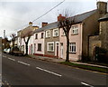
Westgate houses west of Broad Shoard House, Cowbridge
The edge of the curiously named Broad Shoard House http://www.geograph.org.uk/photo/3638789 is on the right.
Image: © Jaggery
Taken: 19 Jan 2012
0.01 miles
2
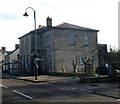
Cowbridge Police Station
Part of the South Wales Police force, the station is alongside the A4222 Westgate.
A sign points right towards the youth centre. http://www.geograph.org.uk/photo/3638801
Image: © Jaggery
Taken: 19 Jan 2012
0.01 miles
3
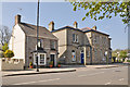
Cowbridge Police Station and Thira Cottage
Image: © Mick Lobb
Taken: 20 Apr 2009
0.01 miles
4
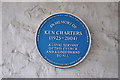
Memorial plaque, United Free Church - Cowbridge
Image: © Mick Lobb
Taken: 20 Apr 2009
0.01 miles
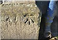
5
Bench Mark, Cowbridge Police Station
The bench mark is on the front of the building adjacent to the right hand rainwater pipe.
Its elevation is shown on the 1906 OS map as 95.4ft
Image: © Guy Butler-Madden
Taken: 23 Feb 2012
0.02 miles
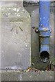
6
Ordnance Survey Cut Mark
This OS cut mark can be found on the Police Station, Westgate. It marks a point 28.983m above mean sea level.
Image: © Adrian Dust
Taken: 19 Apr 2018
0.02 miles
7
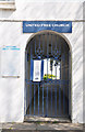
Memorial gates and entrance, United Free Church - Cowbridge
Image: © Mick Lobb
Taken: 20 Apr 2009
0.02 miles
8
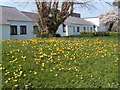
Spring dandelions in old Hall Gardens
The white building is the Health Centre
Image: © Ron Speed
Taken: 18 Apr 2010
0.02 miles
9
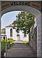
United Free Church - Cowbridge
Cowbridge United Free Church is in Westgate, Cowbridge.
An inter-denominational church it was formed from the uniting of local Congregational, Methodist and Presbyterian churches with 'Ramoth' Baptist Church. It functions independently but under the umbrellas of parent bodies and includes members from all of the main denominations of the Christian faith, as well as those with no particular affiliation, as a free church.
The church operates autonomously. appointing its own minister and is totally self-financing with its day to day management being the responsibility of the Church Council which is elected from among its membership.
Image: © Mick Lobb
Taken: 20 Apr 2009
0.02 miles
10
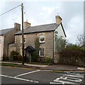
Broad Shoard House, Cowbridge
On the corner of Westgate and The Broad Shoard. Two unknowns here - was the house named after the street, or the street after the house? And what is a shoard?
Image: © Jaggery
Taken: 19 Jan 2012
0.02 miles