IMAGES TAKEN NEAR TO
Plymouth Road, PENARTH, CF64 5DG
Introduction
This page details the photographs taken nearby to Plymouth Road, CF64 5DG by members of the Geograph project.
The Geograph project started in 2005 with the aim of publishing, organising and preserving representative images for every square kilometre of Great Britain, Ireland and the Isle of Man.

There are currently over 7.5m images from over14,400 individuals and you can help contribute to the project by visiting https://www.geograph.org.uk
Image Map
Images are licensed for reuse under creativecommons.org/licenses/by-sa/2.0
Notes
- Clicking on the map will re-center to the selected point.
- The higher the marker number, the further away the image location is from the centre of the postcode.
Image Listing (50 Images Found)
Images are licensed for reuse under creativecommons.org/licenses/by-sa/2.0
Image
Details
Distance
1
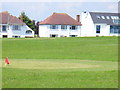
Clifftop Penarth
Houses on Plymouth Road overlooking the recreational lawns and the sea - by the Cliff Walk between Lavernock and Penarth.
Image: © Colin Smith
Taken: 7 Jun 2008
0.07 miles
2
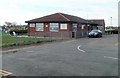
Cioni?s Bistro & Pizzeria, Penarth
Located on Cliff Parade, on the northern side of a miniature golf course. http://www.geograph.org.uk/photo/2192428
Image: © Jaggery
Taken: 24 Nov 2010
0.10 miles
3
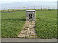
Rotary International Centenary Plinth, Penarth
The plinth is located alongside a footpath known as Cliff Walk. It was donated by the Rotary Club of Penarth to celebrate the centenary year of Rotary International (2005). Rotary's motto, "Service Above Self", exemplifies the humanitarian spirit of the organisation, which carries out community and international projects.
There is a map of the Bristol Channel on the top of the plinth. http://www.geograph.org.uk/photo/2192742
Image: © Jaggery
Taken: 24 Nov 2010
0.10 miles
4
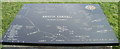
Rotary International map of the Bristol Channel, Penarth
The map is on this plinth. http://www.geograph.org.uk/photo/2192736
Image: © Jaggery
Taken: 24 Nov 2010
0.10 miles
5
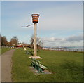
Cliff top beacon, Penarth
The view north along a footpath known as Cliff Walk. The beacon is about 20 metres (70 feet) above sea level, on the edge of the Bristol Channel.
Image: © Jaggery
Taken: 24 Nov 2010
0.10 miles
6
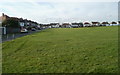
Houses at the edge of a miniature golf course, Penarth
The houses on the left are on Channel View; the longer row of houses is Plymouth Road, viewed across the southern edge of a miniature golf course. http://www.geograph.org.uk/photo/2192428
Image: © Jaggery
Taken: 24 Nov 2010
0.10 miles
7
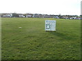
Miniature golf course, Penarth
The course occupies a rectangular area between Plymouth Road, Channel View, Cliff Parade and a cliff-top path. The board shows the price list, and the orientation of the nine holes.
Image: © Jaggery
Taken: 24 Nov 2010
0.10 miles
9
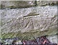
Ordnance Survey Cut Mark
This OS cut mark can be found on the south parapet of the railway bridge. It marks a point 30.949m above mean sea level.
Image: © Adrian Dust
Taken: 25 Sep 2017
0.11 miles
10
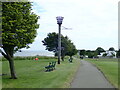
Beacon, Cliff Top Park
The Wales Coast Path in Lower Penarth
Image: © Eirian Evans
Taken: 22 Jun 2021
0.13 miles