IMAGES TAKEN NEAR TO
DINAS POWYS, CF64 4BE
Introduction
This page details the photographs taken nearby to CF64 4BE by members of the Geograph project.
The Geograph project started in 2005 with the aim of publishing, organising and preserving representative images for every square kilometre of Great Britain, Ireland and the Isle of Man.

There are currently over 7.5m images from over14,400 individuals and you can help contribute to the project by visiting https://www.geograph.org.uk
Image Map
Images are licensed for reuse under creativecommons.org/licenses/by-sa/2.0
Notes
- Clicking on the map will re-center to the selected point.
- The higher the marker number, the further away the image location is from the centre of the postcode.
Image Listing (7 Images Found)
Images are licensed for reuse under creativecommons.org/licenses/by-sa/2.0
Image
Details
Distance
1
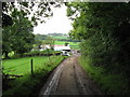
Lane to Beauville Farm, near Dinas Powis
Image: © Gareth James
Taken: 30 Sep 2010
0.09 miles
2
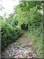
Track between Wrinstone and Beauville Farms
Image: © Gareth James
Taken: 30 Sep 2010
0.10 miles
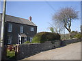
4
Footpath beside Wrinstons House, near Wenvoe
Image: © Gareth James
Taken: 30 Sep 2010
0.20 miles
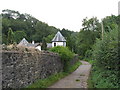
5
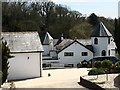
Wrinstone House
Wrinstone House was built in 1880 on the site of an earlier gamekeeper's cottage. A manor was held in this area from the early Norman period.
Image: © Alan Hughes
Taken: 20 Apr 2016
0.20 miles
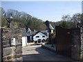
7
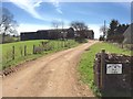
Wrinstone Farm
Entrance to Wrinstone Farm.
Image: © Alan Hughes
Taken: 20 Apr 2016
0.24 miles