IMAGES TAKEN NEAR TO
The Esplanade, PENARTH, CF64 3LA
Introduction
This page details the photographs taken nearby to The Esplanade, CF64 3LA by members of the Geograph project.
The Geograph project started in 2005 with the aim of publishing, organising and preserving representative images for every square kilometre of Great Britain, Ireland and the Isle of Man.

There are currently over 7.5m images from over14,400 individuals and you can help contribute to the project by visiting https://www.geograph.org.uk
Image Map
Images are licensed for reuse under creativecommons.org/licenses/by-sa/2.0
Notes
- Clicking on the map will re-center to the selected point.
- The higher the marker number, the further away the image location is from the centre of the postcode.
Image Listing (249 Images Found)
Images are licensed for reuse under creativecommons.org/licenses/by-sa/2.0
Image
Details
Distance
1
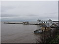
Penarth Swimming Baths
Built in the 1880’s the public baths served the community and visitors for approximately a century. For a while they were converted into a pub, The Inn at the Deep End, before finally being converted into flats.
https://glamarchives.wordpress.com/2018/01/31/penarth-baths/
Image: © Alan Hughes
Taken: 6 Jan 2023
0.00 miles
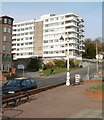
2
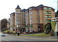
Alexandra Court, Penarth
A modern building of 53 apartments on The Esplanade.
Image: © Jaggery
Taken: 24 Nov 2010
0.01 miles
3
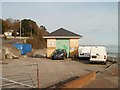
Kymin sewage pumping station, Penarth
Located between Beach Road and the sea shore. A sign http://www.geograph.org.uk/photo/2190376 on the left side of the station defines the no-go area for water skiing
Image: © Jaggery
Taken: 24 Nov 2010
0.01 miles
4
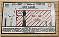
No go area for water skiing, Penarth
A Penarth Water Ski Club sign on Kymin sewage pumping station http://www.geograph.org.uk/photo/2190372 defines the no-go area for water skiing. Surprisingly, the sewage outlet shown on the left is not within the zone...
Image: © Jaggery
Taken: 24 Nov 2010
0.01 miles
5
Seabank flats, Penarth
Seabank is a multi-storey building of about 50 flats, at the southern end of Beach Road, near The Esplanade.
Image: © Jaggery
Taken: 24 Nov 2010
0.01 miles
6
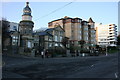
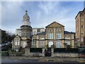
The Esplanade, Penarth
The landward side of The Esplanade, on the junction with Bridgeman Road, opposite the entrance to The Pier. The Victorian building with the elaborate turret is I believe a former municipal swimming baths (please correct if inaccurate) that seems to have been converted to flats. Next to it is a modern apartment block, no doubt its turret is a reference to the Victorian built Esplanade Hotel that previously occupied the site and that was a more attractive building.
Image: © Adrian Platt
Taken: 12 Dec 2009
0.02 miles
7
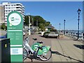
OVO e-bike charging station, Penarth
Situated on The Esplanade by Penarth Pier.
A hired e-bike may be returned to one of the five charging stations in the Vale of Glamorgan or Cardiff Bay area.
The scheme is run by nextbike UK.
Image: © Robin Drayton
Taken: 20 Sep 2021
0.03 miles
8
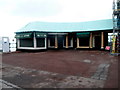
Tony's Pizza Takeaway, Penarth
Located alongside Marina Pavilion. http://www.geograph.org.uk/photo/3785117
Image: © Jaggery
Taken: 9 Dec 2012
0.03 miles
9
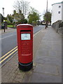
Penarth: postbox № CF64 315, Bridgeman Road
An example of the relatively common 'Type K' design of pillar box dating from 1980. It stands almost at the bottom of Bridgeman Road, with the pier just behind us.
Image: © Chris Downer
Taken: 4 Apr 2012
0.03 miles