IMAGES TAKEN NEAR TO
The Slipway, PENARTH, CF64 1SH
Introduction
This page details the photographs taken nearby to The Slipway, CF64 1SH by members of the Geograph project.
The Geograph project started in 2005 with the aim of publishing, organising and preserving representative images for every square kilometre of Great Britain, Ireland and the Isle of Man.

There are currently over 7.5m images from over14,400 individuals and you can help contribute to the project by visiting https://www.geograph.org.uk
Image Map
Images are licensed for reuse under creativecommons.org/licenses/by-sa/2.0
Notes
- Clicking on the map will re-center to the selected point.
- The higher the marker number, the further away the image location is from the centre of the postcode.
Image Listing (62 Images Found)
Images are licensed for reuse under creativecommons.org/licenses/by-sa/2.0
Image
Details
Distance
1
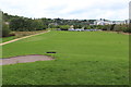
Open space, Penarth
Parkland on what was the site of part of Penarth Dock, viewed from a piece of public art Image
Image: © M J Roscoe
Taken: 23 Aug 2018
0.07 miles
2
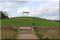
Public Art, Penarth Portway
'Shelter' on mound next to Penarth Portway and is reached by a circular path; the translucent centre of the roof has an inscription in Welsh.
Image: © M J Roscoe
Taken: 23 Aug 2018
0.09 miles
3
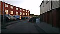
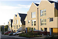
Rear of St Joseph's Mews, Penarth Heights
New houses at St Joseph's Mews, Penarth Heights
Image: © Christopher R Ware
Taken: 23 May 2012
0.13 miles
4
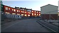
St Joseph's Mews, Penarth Heights
The rear of the new development at Penarth Heights, St Joseph's Mews
Image: © Christopher R Ware
Taken: 23 May 2012
0.14 miles
5

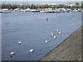
Waterfront, Penarth marina
Surveyed by a seagull on the lamppost
Image: © John Lord
Taken: 5 Jun 2010
0.14 miles
6
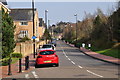
Penarth : Marconi Avenue
Looking along a small road heading through Penarth.
Image: © Lewis Clarke
Taken: 30 Mar 2014
0.15 miles
7
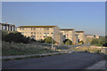
New houses at Royal Close, Penarth Heights
Some of the premier new houses at Penarth Heights
Image: © Christopher R Ware
Taken: 5 Nov 2012
0.15 miles
10
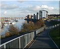
Riverside view, Marconi Avenue, Penarth
The view east from the edge of Marconi Avenue. The buildings along the right (south) bank of the Ely are on Chandlers Quay. http://www.geograph.org.uk/photo/2184311
Image: © Jaggery
Taken: 24 Nov 2010
0.16 miles