IMAGES TAKEN NEAR TO
Paget Road, PENARTH, CF64 1DS
Introduction
This page details the photographs taken nearby to Paget Road, CF64 1DS by members of the Geograph project.
The Geograph project started in 2005 with the aim of publishing, organising and preserving representative images for every square kilometre of Great Britain, Ireland and the Isle of Man.

There are currently over 7.5m images from over14,400 individuals and you can help contribute to the project by visiting https://www.geograph.org.uk
Image Map
Images are licensed for reuse under creativecommons.org/licenses/by-sa/2.0
Notes
- Clicking on the map will re-center to the selected point.
- The higher the marker number, the further away the image location is from the centre of the postcode.
Image Listing (134 Images Found)
Images are licensed for reuse under creativecommons.org/licenses/by-sa/2.0
Image
Details
Distance
1
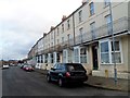
Balconied houses in Paget Road, Penarth
Viewed looking east from the corner of Steep Street. http://www.geograph.org.uk/photo/3737538
Image: © Jaggery
Taken: 9 Dec 2012
0.01 miles
5
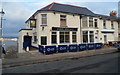
The New Pilot, Penarth
Located at 67 Queen's Road. After an extensive renovation project, The Pilot reopened in September 2012 as The New Pilot. Knife and Fork Food has leased the pub on a 20-year contract from its owners SA Brains. The pub sign and name sign still show The Pilot, but dark blue banners on the pavement show The New Pilot.
Image: © Jaggery
Taken: 9 Dec 2012
0.04 miles
6
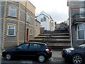
Broad steps up to Queen's Road, Penarth
Steps ascends from Paget Road to Queen's Road. The white building on the left is The New Pilot. http://www.geograph.org.uk/photo/3254164
Image: © Jaggery
Taken: 9 Dec 2012
0.05 miles
7
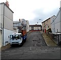
Steep Street, Penarth
A view from Paget Road up Steep Street towards Queen's Road. Visitors from some other parts of Wales would be amused that in Penarth this modest incline is regarded as steep...
Image: © Jaggery
Taken: 9 Dec 2012
0.05 miles
8
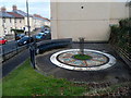
Queen's Road Public Open Space, Penarth
This formerly derelict site was landscaped in 2006 as part of the Penarth Central Renewal Area project 2000-2010 funded by the Vale of Glamorgan Council and the Welsh Assembly Government. The central mosaic seen here, in the form of a compass, was designed by local artist Maureen O'Kane and funded by The Old Penarth Community Forum.
Image: © Jaggery
Taken: 9 Dec 2012
0.06 miles
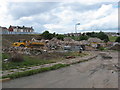
9
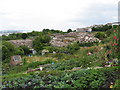
Former Billybanks estate, Penarth
Looking over the allotments to the now-demolished housing estate.
Image: © Gareth James
Taken: 21 Jul 2010
0.07 miles
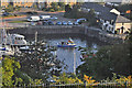
10
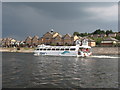
Flats and Aquabus
An aquabus sailing past modern luxury flats at Penarth Marina, under a grey sky shortly after rain and thunder. Photographed from a Cardiff Bay trip boat.
Image: © David Roberts
Taken: 28 Jul 2008
0.07 miles