1
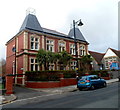
Albert Primary School, Penarth
Image: © Eirian Evans
Taken: 4 May 2019
0.03 miles
2
Albert Primary School, Penarth
Viewed across Albert Road. The school was founded in 1876. The building's Victorian grey stonework is topped by newer roofing. In its early years, the school was for all children up to school leaving age, though schooling did not become mandatory in the UK until 1880, when all children had to attend school until they were 10 years old. In 1889, the school leaving age was raised to 12.
Image: © Jaggery
Taken: 9 Dec 2012
0.03 miles
3
Cliff Street, Penarth
Looking up Cliff Street from Queen's Road towards Lord Street and Coronation Terrace.
Image: © Jaggery
Taken: 9 Dec 2012
0.05 miles
4
Belle Vue Park, Penarth
Belle Vue Park, originally known as Belle Vue Gardens, was created on a triangular plot of land opposite the Council Offices in Albert Road. This land was purchased in 1913 from the Earl of Plymouth, and Belle Vue Gardens was officially opened on May 22nd 1915. Its main feature was the bowling green.
Image: © Eirian Evans
Taken: 4 May 2019
0.05 miles
5
Belle Vue Court, Penarth
A large detached house, 19 Albert Road, has been converted to flats.
Image: © Jaggery
Taken: 9 Dec 2012
0.05 miles
6
Belle Vue Park Bowling Green, Penarth
The bowling green was created in 1915 on the site of a disused quarry (shown on 1870s Ordnance Survey maps). It is inside Belle Vue Park, which was officially opened on May 22nd 1915.
Image: © Jaggery
Taken: 9 Dec 2012
0.06 miles
7
Belle Vue Park, Penarth
This is the NE corner of the triangular park, viewed from the Belle Vue Terrace entrance.
Image: © Jaggery
Taken: 9 Dec 2012
0.06 miles
8
Stanwell Crescent, Penarth
Stanwell Crescent climbs away from the junction of John Street, Queens Road and Maugham Terrace.
Image: © Jaggery
Taken: 9 Dec 2012
0.07 miles
9
Stanwell Crescent, not to mention the hill, Penarth
Cardiff Bay can be seen in the background.
Image: © Ruth Sharville
Taken: 20 Sep 2021
0.07 miles
10
St Augustine's Parish Hall, Penarth
Located in Albert Road, overlooking Belle Vue Park, a short walk from St Augustine’s Church, http://www.geograph.org.uk/photo/3753161
the Parish Hall was opened on April 25th 1995 by the Right Reverend Roy Davies, Bishop of Llandaff.
A wide range of clubs and groups use the hall during the week. It is available to hire for parties, wedding receptions, meetings etc.
Image: © Jaggery
Taken: 9 Dec 2012
0.07 miles


