IMAGES TAKEN NEAR TO
Crossways Street, BARRY, CF63 4PQ
Introduction
This page details the photographs taken nearby to Crossways Street, CF63 4PQ by members of the Geograph project.
The Geograph project started in 2005 with the aim of publishing, organising and preserving representative images for every square kilometre of Great Britain, Ireland and the Isle of Man.

There are currently over 7.5m images from over14,400 individuals and you can help contribute to the project by visiting https://www.geograph.org.uk
Image Map
Images are licensed for reuse under creativecommons.org/licenses/by-sa/2.0
Notes
- Clicking on the map will re-center to the selected point.
- The higher the marker number, the further away the image location is from the centre of the postcode.
Image Listing (134 Images Found)
Images are licensed for reuse under creativecommons.org/licenses/by-sa/2.0
Image
Details
Distance
1
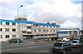
Barry Police HQ, Gladstone Road, Barry
The main Police Station serving the Vale of Glamorgan Division
Image: © Tony Hodge
Taken: 31 Oct 2006
0.04 miles
2
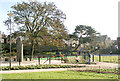
Central park, Barry
This park has recently been refurbished as part of the Town Hall and Library renewal project
Image: © Tony Hodge
Taken: 2 Nov 2006
0.04 miles
3
Gladstone Road, Barry
I've put a close-up of the dove cote on the site as a supplemental
Image: © Tony Hodge
Taken: 3 Nov 2006
0.04 miles
4
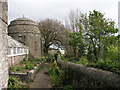
Dove Cote, above Gladstone Road, Barry.
Cadoxton Court
Built in 1871 by the Rev John Hughes alongside the ruins of the medieval court. The 13th century dovecote alongside is one of the largest of its type in Wales..
Description courtesy of barrywales.co.uk website
Image: © Tony Hodge
Taken: 3 Nov 2006
0.04 miles
5
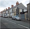
Guthrie Street, Barry
Viewed from the Holton Road end. On the right, closed and shuttered on a Sunday, is Lucy's Boutique.
Image: © Jaggery
Taken: 17 Mar 2013
0.06 miles
6
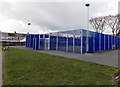
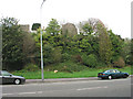
Sports court in Bassett Park, Barry
Bassett Park is located between Bassett Street and Everard Street and fronts onto Holton Road, to the east of Barry town centre. Welsh Government funding of £400,000 through the Barry Regeneration Area programme has transformed the open space into a new play and recreation area.
Image: © Jaggery
Taken: 17 Mar 2013
0.09 miles
7
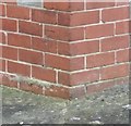
Ordnance Survey Cut Mark
This OS cut mark can be found on No448 Gladstone Road. It marks a point 32.720m above mean sea level.
Image: © Adrian Dust
Taken: 3 Feb 2018
0.09 miles
8
Hydropower and Smokescreen, Barry
Hydropower is a hydroponics shop at 255 Holton Road, on the corner of Brook Street.
Next door is Smokescreen Seedbank Headshop.
Image: © Jaggery
Taken: 17 Mar 2013
0.10 miles
9
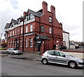
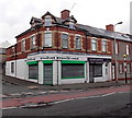
The Tadross Hotel, Barry
The hotel is at 271 Holton Road, on the corner of Bassett Street.
The entrance to the hotel's Bassett Bar is at the left (Bassett Street) corner, seen in this http://www.geograph.org.uk/photo/1897249 view.
Image: © Jaggery
Taken: 17 Mar 2013
0.10 miles
10
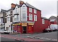
Sandy's Store, Barry
Newsagent, confectioner, tobacconist and off licence at 253 Holton Road, on the corner of Brook Street.
Image: © Jaggery
Taken: 17 Mar 2013
0.10 miles