IMAGES TAKEN NEAR TO
Coronation Street, BARRY, CF63 4JW
Introduction
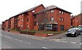
This page details the photographs taken nearby to Coronation Street, CF63 4JW by members of the Geograph project.
The Geograph project started in 2005 with the aim of publishing, organising and preserving representative images for every square kilometre of Great Britain, Ireland and the Isle of Man.

There are currently over 7.5m images from over14,400 individuals and you can help contribute to the project by visiting https://www.geograph.org.uk
Image Map
Images are licensed for reuse under creativecommons.org/licenses/by-sa/2.0
Notes
- Clicking on the map will re-center to the selected point.
- The higher the marker number, the further away the image location is from the centre of the postcode.
Image Listing (245 Images Found)
Images are licensed for reuse under creativecommons.org/licenses/by-sa/2.0
Image
Details
Distance
1
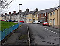
Coronation Street, Barry
Originally named Sydenham Street, Coronation Street bends away from Dock View Road.
The street was renamed after it won the award for the best dressed street in Barry during the King George VI coronation celebrations in the spring of 1937.
Image: © Jaggery
Taken: 6 Jan 2013
0.02 miles
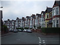
2
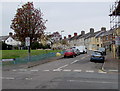
Southern end of Coronation Street, Barry
Coronation Street ascends from Dock View Road. The street was originally Sydenham Street. It was renamed after it won the award for the best dressed street in Barry during the King George VI coronation celebrations in the spring of 1937.
Image: © Jaggery
Taken: 18 Aug 2016
0.05 miles
3
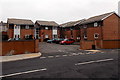
Waverley Court, Dock View Road, Barry
Waverley Court contains 10 flats, set back from the north side of Dock View Road.
Image: © Jaggery
Taken: 6 Jan 2013
0.06 miles
4
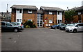
Waverley Court, Dock View Road, Barry
Flats set back from the north side of Dock View Road.
Image: © Jaggery
Taken: 18 Aug 2016
0.06 miles
5
Philippa Freeth Court, Barry
Viewed across Dock View Road opposite the corner of Kingsland Crescent.
Named after a member of staff who died at a tragically young age, Philippa Freeth Court
is a Newydd sheltered housing scheme which officially opened on November 5th 1987.
Image: © Jaggery
Taken: 28 Feb 2013
0.07 miles
6
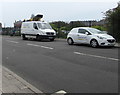
Openreach vehicles in Dock View Road, Barry
Parked near Barry telephone exchange. http://www.geograph.org.uk/photo/3319515 The van has a Versalift. http://www.geograph.org.uk/photo/5083519
Openreach is the infrastructure division of the telecommunications company BT Group.
Image: © Jaggery
Taken: 18 Aug 2016
0.07 miles
7
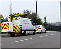
Openreach Versalift van, Dock View Road, Barry
The van is fitted with a Versalift, an access platform which can be extended for working high above street level. Openreach is the infrastructure division of the telecommunications company BT Group.
Image: © Jaggery
Taken: 18 Aug 2016
0.07 miles
9
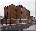
Barry telephone exchange
The Dock View Road building is on the corner of Thompson Street.
Image: © Jaggery
Taken: 6 Jan 2013
0.08 miles
10
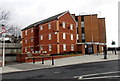
Cwrt Trem yr Ynys flats, Barry
Cwrt Trem yr Ynys (Welsh for Island View Court) is located at the SE end of Thompson Street.
A large telephone exchange http://www.geograph.org.uk/photo/3319515 is behind the flats.
Image: © Jaggery
Taken: 17 Mar 2013
0.08 miles