1
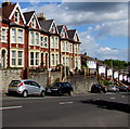
Change of house type, Holton Road, Barry
Viewed from the corner of Wilfred Street.
Image: © Jaggery
Taken: 26 Apr 2017
0.02 miles
2
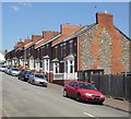
Down Holton Road, Barry
Holton Road descends towards the A4055, viewed from the corner of Hill Street.
Image: © Jaggery
Taken: 26 Apr 2017
0.02 miles
3
Houses above Holton Road, Barry
Steps ascend from Holton Road to houses based about 3 metres above road level.
Viewed from the corner of Hill Street.
Image: © Jaggery
Taken: 26 Apr 2017
0.03 miles
4
Tensing Terrace, Barry
Viewed from Hillary Rise in a Conquest of Everest themed part of Barry. On May 29th 1953, Nepalese Sherpa mountaineer Tensing (or Tenzing) Norgay and New Zealander Edmund Hillary became the first climbers confirmed to have reached the summit of Mount Everest. They were part of the ninth British expedition to Everest, led by John Hunt. Hunt Place http://www.geograph.org.uk/photo/5366664 is nearby.
Image: © Jaggery
Taken: 26 Apr 2017
0.03 miles
5
Corner of Charlotte Place and Rectory Rd, Barry
Image: © John Lord
Taken: 4 Mar 2011
0.04 miles
6
Milward Street, Barry
Viewed from the Holton Road end.
Image: © Jaggery
Taken: 16 Jun 2010
0.04 miles
7
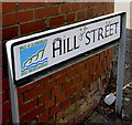
Partly bilingual street name sign, Hill Street, Barry
The Vale of Glamorgan/Bro Morgannwg part of the sign is in English and Welsh.
The street name is in English only.
Image: © Jaggery
Taken: 26 Apr 2017
0.04 miles
8
Three-storey houses, Tensing Terrace, Barry
Viewed from Hillary Rise in a Conquest of Everest themed part of Barry. On May 29th 1953, Nepalese Sherpa mountaineer Tensing (or Tenzing) Norgay and New Zealander Edmund Hillary became the first climbers confirmed to have reached the summit of Mount Everest. They were part of the ninth British expedition to Everest, led by John Hunt. Hunt Place http://www.geograph.org.uk/photo/5366664 is nearby.
Image: © Jaggery
Taken: 26 Apr 2017
0.04 miles
9
Hillary Rise houses, Barry
Located between Hunt Place and Tensing Terrace in a Conquest of Everest themed part of Barry.
On May 29th 1953, Nepalese Sherpa mountaineer Tensing (or Tenzing) Norgay and New Zealander Edmund Hillary became the first climbers confirmed to have reached the summit of Mount Everest. They were part of the ninth British expedition to Everest, led by John Hunt.
Image: © Jaggery
Taken: 26 Apr 2017
0.05 miles
10
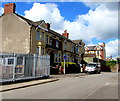
Hill Street houses, Barry
Between Hillary Rise and Holton Road (ahead).
Image: © Jaggery
Taken: 26 Apr 2017
0.05 miles


