IMAGES TAKEN NEAR TO
Hillary Rise, BARRY, CF63 3HZ
Introduction
This page details the photographs taken nearby to Hillary Rise, CF63 3HZ by members of the Geograph project.
The Geograph project started in 2005 with the aim of publishing, organising and preserving representative images for every square kilometre of Great Britain, Ireland and the Isle of Man.

There are currently over 7.5m images from over14,400 individuals and you can help contribute to the project by visiting https://www.geograph.org.uk
Image Map
Images are licensed for reuse under creativecommons.org/licenses/by-sa/2.0
Notes
- Clicking on the map will re-center to the selected point.
- The higher the marker number, the further away the image location is from the centre of the postcode.
Image Listing (154 Images Found)
Images are licensed for reuse under creativecommons.org/licenses/by-sa/2.0
Image
Details
Distance
1
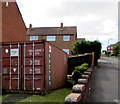
Unusual object in a suburban front garden, Barry
A large metal container, capacity 33 cubic metres, is in the front garden of a Hillary Rise house.
Image: © Jaggery
Taken: 26 Apr 2017
0.00 miles
2
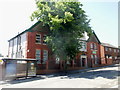
Barry mosque
Located at the eastern end of Holton Road. The building is used for a mosque and is also used by the Muslim Welfare Association of the Vale of Glamorgan.
Image: © Jaggery
Taken: 16 Jun 2010
0.02 miles
3
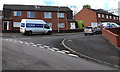
Horizon van on a Barry corner
The Horizon Civil Engineering Ltd van is parked on the corner of Hillary Rise and Hunt Place in late April 2017 near a fenced-off building site on the right. Horizon Civil Engineering Limited is based in Hayes Road, Barry.
Image: © Jaggery
Taken: 26 Apr 2017
0.02 miles
5
Up Hunt Place, Barry
Hunt Place ascends from Hillary Rise towards Holton Road.
Image: © Jaggery
Taken: 26 Apr 2017
0.05 miles
6
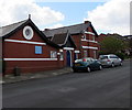
Luchana Mission, Barry
Luchana Mission Free Evangelical Church viewed across Hillary Road from near the corner of Holton Road.
Image: © Jaggery
Taken: 26 Apr 2017
0.05 miles
7
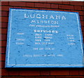
Information board on the wall of Luchana Mission Free Evangelical Church, Barry
Located here. http://www.geograph.org.uk/photo/5366265
Image: © Jaggery
Taken: 26 Apr 2017
0.05 miles
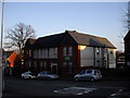
8

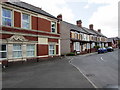
Hillary Rise houses, Barry
Located between Hunt Place and Tensing Terrace in a Conquest of Everest themed part of Barry.
On May 29th 1953, Nepalese Sherpa mountaineer Tensing (or Tenzing) Norgay and New Zealander Edmund Hillary became the first climbers confirmed to have reached the summit of Mount Everest. They were part of the ninth British expedition to Everest, led by John Hunt.
Image: © Jaggery
Taken: 26 Apr 2017
0.05 miles
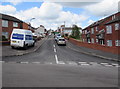
10
Northeast end of Hillary Rise, Barry
Part of Hillary Mews is on the left. Luchana Mission Free Evangelical Church http://www.geograph.org.uk/photo/5366265 is on the right.
Image: © Jaggery
Taken: 26 Apr 2017
0.06 miles