IMAGES TAKEN NEAR TO
Palmerston Road, BARRY, CF63 2YZ
Introduction
This page details the photographs taken nearby to Palmerston Road, CF63 2YZ by members of the Geograph project.
The Geograph project started in 2005 with the aim of publishing, organising and preserving representative images for every square kilometre of Great Britain, Ireland and the Isle of Man.

There are currently over 7.5m images from over14,400 individuals and you can help contribute to the project by visiting https://www.geograph.org.uk
Image Map
Images are licensed for reuse under creativecommons.org/licenses/by-sa/2.0
Notes
- Clicking on the map will re-center to the selected point.
- The higher the marker number, the further away the image location is from the centre of the postcode.
Image Listing (101 Images Found)
Images are licensed for reuse under creativecommons.org/licenses/by-sa/2.0
Image
Details
Distance
1
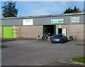
BeeSpoke Cycles, Barry
Located in unit 10 Palmerston Workshops, adjacent to Palmers Vale Business Centre on the west side
of Palmerston Road. The business sells a variety of bicycles including BMX bikes, road bikes, mountain bikes and children's bikes. A bicycle repair service is available.
Edson Print is in unit 11 on the left.
Image: © Jaggery
Taken: 2 Dec 2012
0.02 miles
2
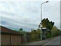
Bus shelter, Palmerston Road, Palmerstown
Image: © David Smith
Taken: 22 Sep 2022
0.03 miles
3
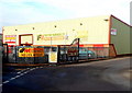
VFM Trade Meat Warehouse, Barry
Located in Palmers Vale Business Centre on the west side of Palmerston Road.
Image: © Jaggery
Taken: 2 Dec 2012
0.03 miles
4

CEG Print & Graphics, Barry
Business in Palmersvale Business Centre, set back from the west side of Palmerston Road.
Image: © Jaggery
Taken: 4 Nov 2016
0.03 miles
5
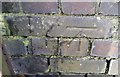
Ordnance Survey Cut Mark
This OS cut mark can be found on the west parapet of the railway bridge. It marks a point 21.296m above mean sea level.
Image: © Adrian Dust
Taken: 3 Feb 2018
0.04 miles
6
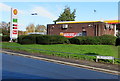
Shell filling station, Palmerston Road, Barry
Prices displayed on November 4th 2016 are 117.9 pence per litre
for unleaded petrol, 120.9 pence per litre for diesel.
Image: © Jaggery
Taken: 4 Nov 2016
0.04 miles
7
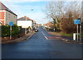
Palmerston Road Barry
Palmerston Road heads north away from Cardiff Road (the A4055).
Blue signs warn of a 7.5 weight tonne limit (across a railway bridge) 300 yards ahead.
Palmerston Road was named after the Palmer family (not Lord Palmerston) who owned much land in this area.
Image: © Jaggery
Taken: 2 Dec 2012
0.04 miles
8
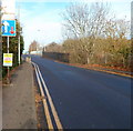
South side of Palmerston Road railway bridge, Barry
Palmerston Road crosses over the Vale of Glamorgan railway line
about 500 metres NE of Cadoxton railway station. http://www.geograph.org.uk/photo/3246730
There is a 7.5 tonne weight limit across the bridge.
Traffic crossing the narrow bridge from this side has priority over oncoming traffic.
Image: © Jaggery
Taken: 2 Dec 2012
0.05 miles
9

Arthur Street traffic calming, Barry
Near the Palmerston Road junction, metal posts mark a narrowing of the roadway to one lane.
Vehicles on the camera side have priority through the narrow part of the road.
Image: © Jaggery
Taken: 4 Nov 2016
0.05 miles
10
Ordnance Survey Cut Mark
This OS cut mark can be found on No50 Palmerston Road. It marks a point 15.002m above mean sea level.
Image: © Adrian Dust
Taken: 3 Feb 2018
0.06 miles