IMAGES TAKEN NEAR TO
Weston Street, BARRY, CF63 2JD
Introduction
This page details the photographs taken nearby to Weston Street, CF63 2JD by members of the Geograph project.
The Geograph project started in 2005 with the aim of publishing, organising and preserving representative images for every square kilometre of Great Britain, Ireland and the Isle of Man.

There are currently over 7.5m images from over14,400 individuals and you can help contribute to the project by visiting https://www.geograph.org.uk
Image Map
Images are licensed for reuse under creativecommons.org/licenses/by-sa/2.0
Notes
- Clicking on the map will re-center to the selected point.
- The higher the marker number, the further away the image location is from the centre of the postcode.
Image Listing (239 Images Found)
Images are licensed for reuse under creativecommons.org/licenses/by-sa/2.0
Image
Details
Distance
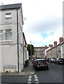
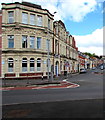
1
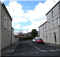
Weston Street, Barry
Viewed across Holmes Street.
Image: © Jaggery
Taken: 26 Apr 2017
0.01 miles
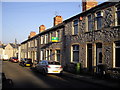
3
Forster Street, Barry
Viewed from Holmes Street.
Image: © Jaggery
Taken: 26 Apr 2017
0.03 miles
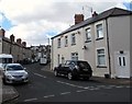
4
Holmes Street, Barry
Viewed across Vere Street from Lower Holmes Street. A William Hill betting shop http://www.geograph.org.uk/photo/5366883 is on the right.
Image: © Jaggery
Taken: 26 Apr 2017
0.03 miles
5
Older and newer street name signs, Weston Street, Barry
On the corner of Holmes Street. The older sign on the wall
is above the newer, more conspicuous, sign near street level.
Image: © Jaggery
Taken: 26 Apr 2017
0.03 miles
6
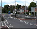
Zebra crossings, Gladstone Road, Barry
Two zebra crossings separated by a central refuge are across
the A4055 Gladstone Road near the Holton Road and Vere Street junctions.
Image: © Jaggery
Taken: 26 Apr 2017
0.03 miles
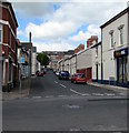
7
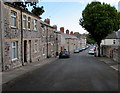
Down Holmes Street, Barry
From trees and metal posts http://www.geograph.org.uk/photo/5366946 at the edge of Quarella Street, Holmes Street descends towards Vere Street.
Image: © Jaggery
Taken: 26 Apr 2017
0.03 miles
8
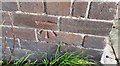
Ordnance Survey Cut Mark
This OS cut mark can be found on No14 Foster Street. It marks a point 14.441m above mean sea level.
Image: © Adrian Dust
Taken: 3 Feb 2018
0.04 miles
9
Cadoxton Conservative Club & Institute, Vere Street, Barry
Located in the former Osborne Hotel on the corner of Gladstone Road.
Image: © Jaggery
Taken: 26 Apr 2017
0.04 miles
10
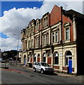
Cadoxton Conservative Club & Institute, Barry
The Vere Street side of the club located in the former Osborne Hotel on the corner of Gladstone Road.
Image: © Jaggery
Taken: 26 Apr 2017
0.04 miles